Ziabar (Gaskar) geodata
Ziabar (Gaskar) (Gīlān) is a populated place; located in Iran in Asia/Tehran (GMT+3.5) time zone. With population of 4,500 people, there are 214 cities with bigger population in this country. Compared to other cities in Iran, 90.5% of cities are located further ↓South; 68.9% of cities are located further →East and 96.8% of cities have higher elevation than Ziabar (Gaskar). Note1


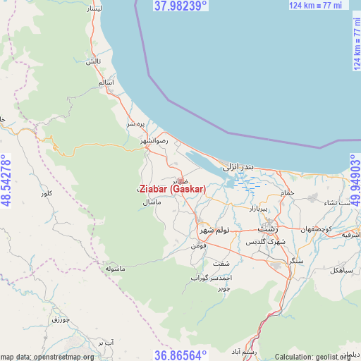
Ziabar (Gaskar) GPS coordinates[2]
37° 25' 33.96" North, 49° 14' 45.24" East
| Map corner | latitude | longitude |
|---|---|---|
| Upper-left | 37.98239°, | 48.54278° |
| Center: | 37.4261°, | 49.2459° |
| Lower-right: | 36.86564°, | 49.94903° |
| Map W x H: | 124.2×124.2 km | = 77.2×77.2mi |
| max Lat: | 39.6482° ⇑9.5% North |
| Ziabar (Gaskar): | 37.4261° |
| min Lat: | ⇓90.5% South 25.2919° |
| min Long | Ziabar (Gaskar) | max Long |
| 44.38416° | 49.2459° | 61.9965° |
| W 31.1%⇐ | ⇒68.9% E |
Elevation
Elevation of Ziabar (Gaskar) is -12 m = -39 ft, and this is 1061 m = 3481 ft below average elevation for this country.
| Max E: |
2564 m = 8412 ft | 96.8% |
| Avg. | 1049 m = 3442 ft | |
| Ziabar (Gaskar) | -12 m = -39 ft | |
Min E: |
-24 m = -79 ft | 3.2% |
See also: Iran elevation on elevation.city.
Geographical zone
Ziabar (Gaskar) is located in North temperate zone (between Tropic of Cancer and the Arctic Circle). Distance of this Northern Tropic circle is 1555.5 km =966.5 mi to South.| Distance of | km | miles | from Ziabar (Gaskar) |
|---|---|---|---|
| North Pole | 5845.7 | 3632.3 | to North |
| Arctic Circle | 3239.8 | 2013.1 | to North |
| Tropic Cancer | 1555.5 | 966.5 | to South |
| Equator | 4161.4 | 2585.8 | to South |


Nearby cities:
15 places around Ziabar (Gaskar): (largest is in red/bold)
• Bandar-e Anzalī
19.4 km =12.1 mi,  74°
74°
• Fūman
23.2 km =14.4 mi,  165°
165°
• Hashtpar
51 km =31.7 mi,  323°
323°
• Khalkhāl
66.7 km =41.4 mi,  288°
288°
• Lāhījān
71.9 km =44.7 mi,  110°
110°
• Māsāl
12.2 km =7.6 mi,  234°
234°
• Māsūleh
37.7 km =23.4 mi,  216°
216°
• Pā’īn-e Bāzār-e Rūdbār
69.1 km =42.9 mi, 166°
• Rasht
34.6 km =21.5 mi,  118°
118°
• Reẕvānshahr
16.8 km =10.4 mi,  325°
325°
• Shaft
31.5 km =19.6 mi,  154°
154°
• Sīāhkal
63.1 km =39.2 mi, 118°
• Ābbar
61.1 km =38 mi,  204°
204°
• Āstāneh-ye Ashrafīyeh
64.2 km =39.9 mi, 106°
• Şowme‘eh Sarā
15.2 km =9.4 mi,  156°
156°
Sources, notices
• [Note1] Compared only with cities in Iran existing in our database
• [Src1] Map data: © OpenStreetMap contributors (CC-BY-SA)
• [Src2] Other city data from geonames.org with taken over terms of usage.
• [Src3] Geographical zone / Annual Mean Temperature by Robert A. Rohde @ Wikipedia
