Āstāneh-ye Ashrafīyeh geodata
Āstāneh-ye Ashrafīyeh (Gīlān) is a seat of a second-order administrative division; located in Iran in Asia/Tehran (GMT+3.5) time zone. With population of 42,784 people, there are 148 cities with bigger population in this country. Compared to other cities in Iran, 88% of cities are located further ↓South; 63.3% of cities are located further →East and 96.6% of cities have higher elevation than Āstāneh-ye Ashrafīyeh. Note1


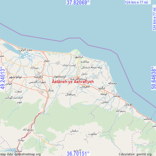
Āstāneh-ye Ashrafīyeh GPS coordinates[2]
37° 15' 47.448" North, 49° 56' 35.7" East
| Map corner | latitude | longitude |
|---|---|---|
| Upper-left | 37.82069°, | 49.24013° |
| Center: | 37.26318°, | 49.94325° |
| Lower-right: | 36.70151°, | 50.64638° |
| Map W x H: | 124.4×124.4 km | = 77.3×77.3mi |
| max Lat: | 39.6482° ⇑12% North |
| Āstāneh-ye Ashrafīyeh: | 37.26318° |
| min Lat: | ⇓88% South 25.2919° |
| min Long | Āstāneh-ye As | max Long |
| 44.38416° | 49.94325° | 61.9965° |
| W 36.7%⇐ | ⇒63.3% E |
Elevation
Elevation of Āstāneh-ye Ashrafīyeh is -8 m = -26 ft, and this is 1057 m = 3468 ft below average elevation for this country.
| Max E: |
2564 m = 8412 ft | 96.6% |
| Avg. | 1049 m = 3442 ft | |
| Āstāneh-ye Ashrafīyeh | -8 m = -26 ft | |
Min E: |
-24 m = -79 ft | 3.4% |
See also: Āstāneh-ye Ashrafīyeh elevation on elevation.city.
Geographical zone
Āstāneh-ye Ashrafīyeh is located in North temperate zone (between Tropic of Cancer and the Arctic Circle). Distance of this Northern Tropic circle is 1537.4 km =955.3 mi to South.| Distance of | km | miles | from Āstāneh-ye Ashrafīyeh |
|---|---|---|---|
| North Pole | 5863.8 | 3643.6 | to North |
| Arctic Circle | 3257.9 | 2024.4 | to North |
| Tropic Cancer | 1537.4 | 955.3 | to South |
| Equator | 4143.3 | 2574.5 | to South |


Nearby cities:
15 places around Āstāneh-ye Ashrafīyeh: (largest is in red/bold)
• Amlash
28.5 km =17.7 mi,  130°
130°
• Bandar-e Anzalī
48.8 km =30.3 mi,  298°
298°
• Fūman
56 km =34.8 mi,  265°
265°
• Langarūd
20 km =12.4 mi,  112°
112°
• Lāhījān
8.8 km =5.5 mi,  138°
138°
• Māsāl
72.5 km =45 mi,  278°
278°
• Pādegān-e Manjīl
74.5 km =46.3 mi,  218°
218°
• Pā’īn-e Bāzār-e Rūdbār
67.2 km =41.8 mi, 223°
• Rasht
31.4 km =19.5 mi, 272°
• Rāmsar
73.4 km =45.6 mi,  121°
121°
• Rūdsar
33.9 km =21.1 mi, 114°
• Shaft
49.2 km =30.6 mi,  257°
257°
• Sīāhkal
13.8 km =8.6 mi,  207°
207°
• Ziabar (Gaskar)
64.2 km =39.9 mi,  286°
286°
• Şowme‘eh Sarā
55.7 km =34.6 mi, 274°
Sources, notices
• [Note1] Compared only with cities in Iran existing in our database
• [Src1] Map data: © OpenStreetMap contributors (CC-BY-SA)
• [Src2] Other city data from geonames.org with taken over terms of usage.
• [Src3] Geographical zone / Annual Mean Temperature by Robert A. Rohde @ Wikipedia
