Ābbar geodata
Ābbar (Zanjan) is a seat of a second-order administrative division; located in Iran in Asia/Tehran (GMT+3.5) time zone. In our database, there are 232 cities with bigger population. Compared to other cities in Iran, 82.1% of cities are located further ↓South; 72.1% of cities are located further →East and 71.4% of cities have higher elevation than Ābbar. Note1


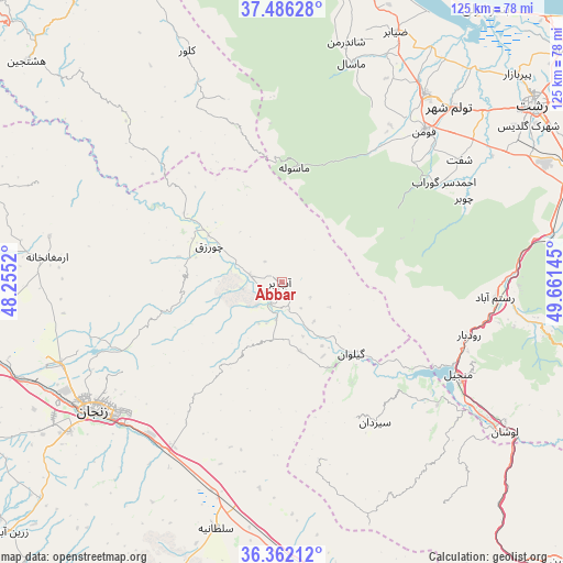
Ābbar GPS coordinates[2]
36° 55' 34.572" North, 48° 57' 29.952" East
| Map corner | latitude | longitude |
|---|---|---|
| Upper-left | 37.48628°, | 48.2552° |
| Center: | 36.92627°, | 48.95832° |
| Lower-right: | 36.36212°, | 49.66145° |
| Map W x H: | 125×125 km | = 77.7×77.7mi |
| max Lat: | 39.6482° ⇑17.9% North |
| Ābbar: | 36.92627° |
| min Lat: | ⇓82.1% South 25.2919° |
| min Long | Ābbar | max Long |
| 44.38416° | 48.95832° | 61.9965° |
| W 27.9%⇐ | ⇒72.1% E |
Elevation
Elevation of Ābbar is 624 m = 2047 ft, and this is 425 m = 1394 ft below average elevation for this country.
| Max E: |
2564 m = 8412 ft | 71.4% |
| Avg. | 1049 m = 3442 ft | |
| Ābbar | 624 m = 2047 ft | |
Min E: |
-24 m = -79 ft | 28.6% |
See also: Iran elevation on elevation.city.
Geographical zone
Ābbar is located in North temperate zone (between Tropic of Cancer and the Arctic Circle). Distance of this Northern Tropic circle is 1499.9 km =932 mi to South.| Distance of | km | miles | from Ābbar |
|---|---|---|---|
| North Pole | 5901.2 | 3666.8 | to North |
| Arctic Circle | 3295.4 | 2047.7 | to North |
| Tropic Cancer | 1499.9 | 932 | to South |
| Equator | 4105.8 | 2551.2 | to South |


Nearby cities:
15 places around Ābbar: (largest is in red/bold)
• Alvand
70.1 km =43.6 mi,  164°
164°
• Bandar-e Anzalī
75.2 km =46.7 mi,  36°
36°
• Fūman
45.6 km =28.3 mi, 43°
• Khorramdarreh
82.6 km =51.3 mi,  165°
165°
• Māsāl
51 km =31.7 mi,  17°
17°
• Māsūleh
25.6 km =15.9 mi,  6°
6°
• Pādegān-e Manjīl
45.6 km =28.3 mi,  116°
116°
• Pā’īn-e Bāzār-e Rūdbār
43.2 km =26.8 mi,  105°
105°
• Rasht
68.1 km =42.3 mi,  55°
55°
• Reẕvānshahr
71.1 km =44.2 mi, 12°
• Shaft
47.7 km =29.6 mi, 55°
• Zanjān
49.6 km =30.8 mi,  235°
235°
• Zarrīnābād
82.1 km =51 mi,  227°
227°
• Ziabar (Gaskar)
61.1 km =38 mi, 24°
• Şowme‘eh Sarā
52.3 km =32.5 mi, 37°
Sources, notices
• [Note1] Compared only with cities in Iran existing in our database
• [Src1] Map data: © OpenStreetMap contributors (CC-BY-SA)
• [Src2] Other city data from geonames.org with taken over terms of usage.
• [Src3] Geographical zone / Annual Mean Temperature by Robert A. Rohde @ Wikipedia
