Şowme‘eh Sarā geodata
Şowme‘eh Sarā (Gīlān) is a seat of a second-order administrative division; located in Iran in Asia/Tehran (GMT+3.5) time zone. In our database, there are 232 cities with bigger population. Compared to other cities in Iran, 88.9% of cities are located further ↓South; 68.3% of cities are located further →East and 93.2% of cities have higher elevation than Şowme‘eh Sarā. Note1


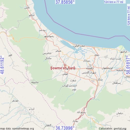
Şowme‘eh Sarā GPS coordinates[2]
37° 18' 4.824" North, 49° 18' 54.144" East
| Map corner | latitude | longitude |
|---|---|---|
| Upper-left | 37.85856°, | 48.61192° |
| Center: | 37.30134°, | 49.31504° |
| Lower-right: | 36.73996°, | 50.01817° |
| Map W x H: | 124.4×124.4 km | = 77.3×77.3mi |
| max Lat: | 39.6482° ⇑11.1% North |
| Şowme‘eh Sarā: | 37.30134° |
| min Lat: | ⇓88.9% South 25.2919° |
| min Long | Şowme‘eh Sar | max Long |
| 44.38416° | 49.31504° | 61.9965° |
| W 31.7%⇐ | ⇒68.3% E |
Elevation
Elevation of Şowme‘eh Sarā is 7 m = 23 ft, and this is 1042 m = 3419 ft below average elevation for this country.
| Max E: |
2564 m = 8412 ft | 93.2% |
| Avg. | 1049 m = 3442 ft | |
| Şowme‘eh Sarā | 7 m = 23 ft | |
Min E: |
-24 m = -79 ft | 6.8% |
See also: Iran elevation on elevation.city.
Geographical zone
Şowme‘eh Sarā is located in North temperate zone (between Tropic of Cancer and the Arctic Circle). Distance of this Northern Tropic circle is 1541.6 km =957.9 mi to South.| Distance of | km | miles | from Şowme‘eh Sarā |
|---|---|---|---|
| North Pole | 5859.5 | 3640.9 | to North |
| Arctic Circle | 3253.7 | 2021.8 | to North |
| Tropic Cancer | 1541.6 | 957.9 | to South |
| Equator | 4147.5 | 2577.1 | to South |


Nearby cities:
15 places around Şowme‘eh Sarā: (largest is in red/bold)
• Bandar-e Anzalī
22.9 km =14.2 mi,  33°
33°
• Fūman
8.6 km =5.3 mi,  181°
181°
• Hashtpar
65.9 km =40.9 mi,  326°
326°
• Lāhījān
62.4 km =38.8 mi,  99°
99°
• Māsāl
17.5 km =10.9 mi,  293°
293°
• Māsūleh
33.1 km =20.6 mi,  240°
240°
• Pādegān-e Manjīl
62.9 km =39.1 mi,  171°
171°
• Pā’īn-e Bāzār-e Rūdbār
54.3 km =33.7 mi, 169°
• Rasht
24.4 km =15.2 mi, 96°
• Reẕvānshahr
31.8 km =19.8 mi, 330°
• Shaft
16.4 km =10.2 mi,  152°
152°
• Sīāhkal
51.9 km =32.2 mi,  108°
108°
• Ziabar (Gaskar)
15.2 km =9.4 mi,  336°
336°
• Ābbar
52.3 km =32.5 mi,  217°
217°
• Āstāneh-ye Ashrafīyeh
55.7 km =34.6 mi,  94°
94°
Sources, notices
• [Note1] Compared only with cities in Iran existing in our database
• [Src1] Map data: © OpenStreetMap contributors (CC-BY-SA)
• [Src2] Other city data from geonames.org with taken over terms of usage.
• [Src3] Geographical zone / Annual Mean Temperature by Robert A. Rohde @ Wikipedia
