Tabriz geodata
Tabriz (East Azerbaijan) is a seat of a first-order administrative division; located in Iran in Asia/Tehran (GMT+3.5) time zone. With population of 1,424,641 people, there are 4 cities with bigger population in this country. Compared to other cities in Iran, 94.8% of cities are located further ↓South; 92.1% of cities are located further →East and 64.6% of cities have lower elevation than Tabriz. Note1


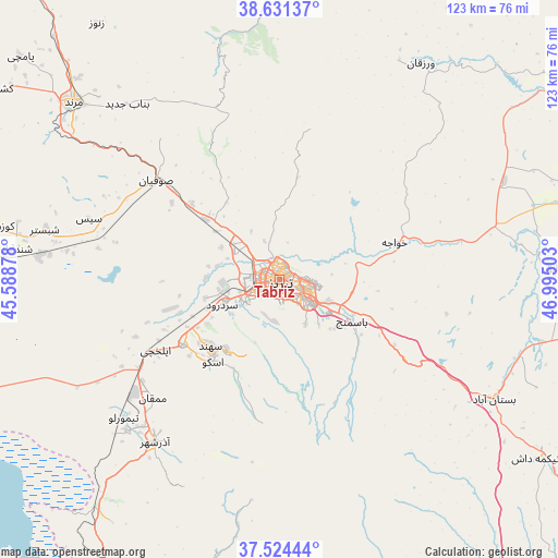
Tabriz GPS coordinates[2]
38° 4' 48" North, 46° 17' 30.84" East
| Map corner | latitude | longitude |
|---|---|---|
| Upper-left | 38.63137°, | 45.58878° |
| Center: | 38.08°, | 46.2919° |
| Lower-right: | 37.52444°, | 46.99503° |
| Map W x H: | 123.1×123.1 km | = 76.5×76.5mi |
| max Lat: | 39.6482° ⇑5.2% North |
| Tabriz: | 38.08° |
| min Lat: | ⇓94.8% South 25.2919° |
| min Long | Tabriz | max Long |
| 44.38416° | 46.2919° | 61.9965° |
| W 7.9%⇐ | ⇒92.1% E |
Elevation
Elevation of Tabriz is 1396 m = 4580 ft, and this is 347 m = 1138 ft above average elevation for this country.
| Max E: |
2564 m = 8412 ft | 35.4% |
| Tabriz | 1396 m 4580 ft | |
| Avg. | 1049 m = 3442 ft | |
Min E: |
-24 m = -79 ft | 64.6% |
See also: Tabriz elevation on elevation.city.
Geographical zone
Tabriz is located in North temperate zone (between Tropic of Cancer and the Arctic Circle). Distance of this Northern Tropic circle is 1628.2 km =1011.7 mi to South.| Distance of | km | miles | from Tabriz |
|---|---|---|---|
| North Pole | 5773 | 3587.2 | to North |
| Arctic Circle | 3167.1 | 1967.9 | to North |
| Tropic Cancer | 1628.2 | 1011.7 | to South |
| Equator | 4234.1 | 2630.9 | to South |


Nearby cities:
15 places around Tabriz: (largest is in red/bold)
• Ahar
81 km =50.3 mi,  56°
56°
• Bonāb
84.8 km =52.7 mi,  194°
194°
• Bostānābād
54.3 km =33.7 mi,  118°
118°
• Hashtrūd
94.5 km =58.7 mi,  135°
135°
• Herīs
74.5 km =46.3 mi,  75°
75°
• Kandovān
31.9 km =19.8 mi, 186°
• Malekān
105.5 km =65.6 mi, 189°
• Marand
59.8 km =37.2 mi,  310°
310°
• Marāgheh
76.6 km =47.6 mi,  183°
183°
• Mīāb
81.2 km =50.5 mi,  328°
328°
• Oskū
23.6 km =14.7 mi,  218°
218°
• Shabestar
52.7 km =32.7 mi,  282°
282°
• Varazqān
68 km =42.3 mi,  346°
346°
• Āz̄arshahr
45.1 km =28 mi, 217°
• ‘Ajab Shīr
75.5 km =46.9 mi,  207°
207°
Sources, notices
• [Note1] Compared only with cities in Iran existing in our database
• [Src1] Map data: © OpenStreetMap contributors (CC-BY-SA)
• [Src2] Other city data from geonames.org with taken over terms of usage.
• [Src3] Geographical zone / Annual Mean Temperature by Robert A. Rohde @ Wikipedia
