Ahar geodata
Ahar (East Azerbaijan) is a seat of a second-order administrative division; located in Iran in Asia/Tehran (GMT+3.5) time zone. With population of 94,348 people, there are 74 cities with bigger population in this country. Compared to other cities in Iran, 97.1% of cities are located further ↓South; 87.3% of cities are located further →East and 60.5% of cities have lower elevation than Ahar. Note1


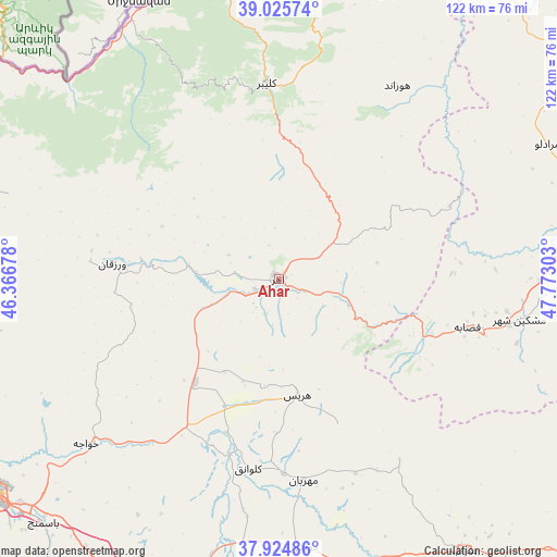
Ahar GPS coordinates[2]
38° 28' 38.64" North, 47° 4' 11.64" East
| Map corner | latitude | longitude |
|---|---|---|
| Upper-left | 39.02574°, | 46.36678° |
| Center: | 38.4774°, | 47.0699° |
| Lower-right: | 37.92486°, | 47.77303° |
| Map W x H: | 122.4×122.4 km | = 76.1×76.1mi |
| max Lat: | 39.6482° ⇑2.9% North |
| Ahar: | 38.4774° |
| min Lat: | ⇓97.1% South 25.2919° |
| min Long | Ahar | max Long |
| 44.38416° | 47.0699° | 61.9965° |
| W 12.7%⇐ | ⇒87.3% E |
Elevation
Elevation of Ahar is 1336 m = 4383 ft, and this is 287 m = 942 ft above average elevation for this country.
| Max E: |
2564 m = 8412 ft | 39.5% |
| Ahar | 1336 m 4383 ft | |
| Avg. | 1049 m = 3442 ft | |
Min E: |
-24 m = -79 ft | 60.5% |
See also: Ahar elevation on elevation.city.
Geographical zone
Ahar is located in North temperate zone (between Tropic of Cancer and the Arctic Circle). Distance of this Northern Tropic circle is 1672.4 km =1039.2 mi to South.| Distance of | km | miles | from Ahar |
|---|---|---|---|
| North Pole | 5728.8 | 3559.7 | to North |
| Arctic Circle | 3122.9 | 1940.5 | to North |
| Tropic Cancer | 1672.4 | 1039.2 | to South |
| Equator | 4278.3 | 2658.4 | to South |


Nearby cities:
15 places around Ahar: (largest is in red/bold)
• Ardabīl
109.6 km =68.1 mi,  103°
103°
• Bostānābād
73.1 km =45.4 mi,  196°
196°
• Germī
106.5 km =66.2 mi,  55°
55°
• Hashtrūd
111.1 km =69 mi,  180°
180°
• Herīs
25.8 km =16 mi,  170°
170°
• Kaleybar
43.2 km =26.8 mi,  356°
356°
• Kandovān
104.5 km =64.9 mi,  223°
223°
• Khomārlū
74.7 km =46.4 mi, 357°
• Meshgīn Shahr
54 km =33.6 mi, 99°
• Nīr
94.9 km =59 mi,  121°
121°
• Omīdcheh
95.8 km =59.5 mi, 102°
• Oskū
103.7 km =64.4 mi,  232°
232°
• Sarāb
72.3 km =44.9 mi,  145°
145°
• Tabriz
81 km =50.3 mi,  236°
236°
• Varazqān
86.1 km =53.5 mi,  284°
284°
Sources, notices
• [Note1] Compared only with cities in Iran existing in our database
• [Src1] Map data: © OpenStreetMap contributors (CC-BY-SA)
• [Src2] Other city data from geonames.org with taken over terms of usage.
• [Src3] Geographical zone / Annual Mean Temperature by Robert A. Rohde @ Wikipedia
