Kandovān geodata
Kandovān (East Azerbaijan) is a populated place; located in Iran in Asia/Tehran (GMT+3.5) time zone. With population of 601 people, there are 230 cities with bigger population in this country. Compared to other cities in Iran, 93.2% of cities are located further ↓South; 92.5% of cities are located further →East and 97.3% of cities have lower elevation than Kandovān. Note1


Kandovān GPS coordinates[2]
37° 47' 41.64" North, 46° 14' 55.32" East
| Map corner | latitude | longitude |
|---|---|---|
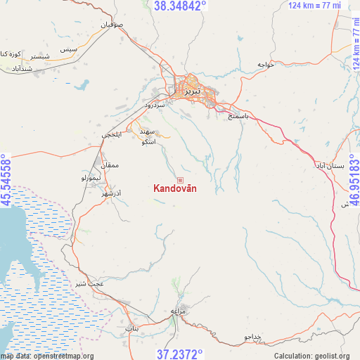
| Upper-left | 38.34842°, | 45.54558° |
| Center: | 37.7949°, | 46.2487° |
| Lower-right: | 37.2372°, | 46.95183° |
| Map W x H: | 123.6×123.6 km | = 76.8×76.8mi |
| max Lat: | 39.6482° ⇑6.8% North |
| Kandovān: | 37.7949° |
| min Lat: | ⇓93.2% South 25.2919° |
| min Long | Kandovān | max Long |
| 44.38416° | 46.2487° | 61.9965° |
| W 7.5%⇐ | ⇒92.5% E |
Elevation
Elevation of Kandovān is 2224 m = 7297 ft, and this is 1175 m = 3855 ft above average elevation for this country.
| Max E: |
2564 m = 8412 ft | 2.7% |
| Kandovān | 2224 m 7297 ft | |
| Avg. | 1049 m = 3442 ft | |
Min E: |
-24 m = -79 ft | 97.3% |
See also: Iran elevation on elevation.city.
Geographical zone
Kandovān is located in North temperate zone (between Tropic of Cancer and the Arctic Circle). Distance of this Northern Tropic circle is 1596.5 km =992 mi to South.| Distance of | km | miles | from Kandovān |
|---|---|---|---|
| North Pole | 5804.7 | 3606.9 | to North |
| Arctic Circle | 3198.8 | 1987.6 | to North |
| Tropic Cancer | 1596.5 | 992 | to South |
| Equator | 4202.4 | 2611.2 | to South |


Nearby cities:
15 places around Kandovān: (largest is in red/bold)
• Ahar
104.5 km =64.9 mi,  43°
43°
• Bonāb
53.3 km =33.1 mi,  198°
198°
• Bostānābād
51.8 km =32.2 mi,  83°
83°
• Hashtrūd
78.9 km =49 mi,  116°
116°
• Herīs
91.2 km =56.7 mi,  56°
56°
• Malekān
73.7 km =45.8 mi,  190°
190°
• Marand
82.2 km =51.1 mi,  329°
329°
• Marāgheh
44.8 km =27.8 mi,  181°
181°
• Mīāndoāb
92.9 km =57.7 mi, 187°
• Oskū
17.4 km =10.8 mi,  320°
320°
• Shabestar
64.2 km =39.9 mi,  311°
311°
• Tabriz
31.9 km =19.8 mi,  6°
6°
• Varazqān
98.6 km =61.3 mi,  353°
353°
• Āz̄arshahr
24.1 km =15 mi,  260°
260°
• ‘Ajab Shīr
47.1 km =29.3 mi,  221°
221°
Sources, notices
• [Note1] Compared only with cities in Iran existing in our database
• [Src1] Map data: © OpenStreetMap contributors (CC-BY-SA)
• [Src2] Other city data from geonames.org with taken over terms of usage.
• [Src3] Geographical zone / Annual Mean Temperature by Robert A. Rohde @ Wikipedia
