Hashtrūd geodata
Hashtrūd (East Azerbaijan) is a seat of a second-order administrative division; located in Iran in Asia/Tehran (GMT+3.5) time zone. With population of 16,888 people, there are 200 cities with bigger population in this country. Compared to other cities in Iran, 91.6% of cities are located further ↓South; 88% of cities are located further →East and 80% of cities have lower elevation than Hashtrūd. Note1


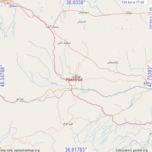
Hashtrūd GPS coordinates[2]
37° 28' 40.44" North, 47° 3' 2.88" East
| Map corner | latitude | longitude |
|---|---|---|
| Upper-left | 38.0338°, | 46.34768° |
| Center: | 37.4779°, | 47.0508° |
| Lower-right: | 36.91783°, | 47.75393° |
| Map W x H: | 124.1×124.1 km | = 77.1×77.1mi |
| max Lat: | 39.6482° ⇑8.4% North |
| Hashtrūd: | 37.4779° |
| min Lat: | ⇓91.6% South 25.2919° |
| min Long | Hashtrūd | max Long |
| 44.38416° | 47.0508° | 61.9965° |
| W 12%⇐ | ⇒88% E |
Elevation
Elevation of Hashtrūd is 1651 m = 5417 ft, and this is 602 m = 1975 ft above average elevation for this country.
| Max E: |
2564 m = 8412 ft | 20% |
| Hashtrūd | 1651 m 5417 ft | |
| Avg. | 1049 m = 3442 ft | |
Min E: |
-24 m = -79 ft | 80% |
See also: Iran elevation on elevation.city.
Geographical zone
Hashtrūd is located in North temperate zone (between Tropic of Cancer and the Arctic Circle). Distance of this Northern Tropic circle is 1561.2 km =970.1 mi to South.| Distance of | km | miles | from Hashtrūd |
|---|---|---|---|
| North Pole | 5839.9 | 3628.7 | to North |
| Arctic Circle | 3234 | 2009.5 | to North |
| Tropic Cancer | 1561.2 | 970.1 | to South |
| Equator | 4167.2 | 2589.4 | to South |


Nearby cities:
15 places around Hashtrūd: (largest is in red/bold)
• Bonāb
89.2 km =55.4 mi,  260°
260°
• Bostānābād
45.1 km =28 mi,  335°
335°
• Herīs
85.8 km =53.3 mi,  3°
3°
• Kandovān
78.9 km =49 mi,  296°
296°
• Malekān
91.7 km =57 mi,  246°
246°
• Marāgheh
72.3 km =44.9 mi, 262°
• Māhneshān
98.4 km =61.1 mi,  145°
145°
• Mīāndoāb
100.9 km =62.7 mi,  235°
235°
• Mīāneh
59 km =36.7 mi,  96°
96°
• Oskū
95 km =59 mi, 300°
• Qarah Āghāj
32.3 km =20.1 mi, 153°
• Sarāb
66.9 km =41.6 mi,  39°
39°
• Shāhīn Dezh
98.6 km =61.3 mi,  205°
205°
• Tabriz
94.5 km =58.7 mi,  315°
315°
• Āz̄arshahr
99.5 km =61.8 mi,  288°
288°
Sources, notices
• [Note1] Compared only with cities in Iran existing in our database
• [Src1] Map data: © OpenStreetMap contributors (CC-BY-SA)
• [Src2] Other city data from geonames.org with taken over terms of usage.
• [Src3] Geographical zone / Annual Mean Temperature by Robert A. Rohde @ Wikipedia
