Āz̄arshahr geodata
Āz̄arshahr (East Azerbaijan) is a seat of a second-order administrative division; located in Iran in Asia/Tehran (GMT+3.5) time zone. In our database, there are 232 cities with bigger population. Compared to other cities in Iran, 93% of cities are located further ↓South; 95.2% of cities are located further →East and 64.2% of cities have lower elevation than Āz̄arshahr. Note1


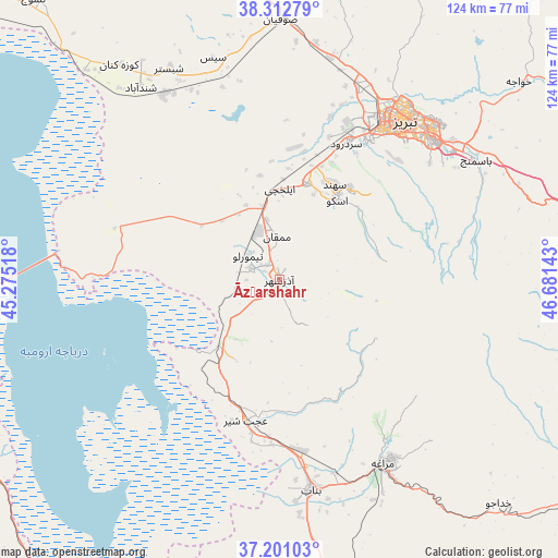
Āz̄arshahr GPS coordinates[2]
37° 45' 32.4" North, 45° 58' 41.88" East
| Map corner | latitude | longitude |
|---|---|---|
| Upper-left | 38.31279°, | 45.27518° |
| Center: | 37.759°, | 45.9783° |
| Lower-right: | 37.20103°, | 46.68143° |
| Map W x H: | 123.6×123.6 km | = 76.8×76.8mi |
| max Lat: | 39.6482° ⇑7% North |
| Āz̄arshahr: | 37.759° |
| min Lat: | ⇓93% South 25.2919° |
| min Long | Āz̄arshahr | max Long |
| 44.38416° | 45.9783° | 61.9965° |
| W 4.8%⇐ | ⇒95.2% E |
Elevation
Elevation of Āz̄arshahr is 1386 m = 4547 ft, and this is 337 m = 1106 ft above average elevation for this country.
| Max E: |
2564 m = 8412 ft | 35.8% |
| Āz̄arshahr | 1386 m 4547 ft | |
| Avg. | 1049 m = 3442 ft | |
Min E: |
-24 m = -79 ft | 64.2% |
See also: Iran elevation on elevation.city.
Geographical zone
Āz̄arshahr is located in North temperate zone (between Tropic of Cancer and the Arctic Circle). Distance of this Northern Tropic circle is 1592.5 km =989.5 mi to South.| Distance of | km | miles | from Āz̄arshahr |
|---|---|---|---|
| North Pole | 5808.7 | 3609.4 | to North |
| Arctic Circle | 3202.8 | 1990.1 | to North |
| Tropic Cancer | 1592.5 | 989.5 | to South |
| Equator | 4198.4 | 2608.8 | to South |


Nearby cities:
15 places around Āz̄arshahr: (largest is in red/bold)
• Bonāb
47 km =29.2 mi,  171°
171°
• Bostānābād
75.9 km =47.2 mi,  82°
82°
• Hashtrūd
99.5 km =61.8 mi,  108°
108°
• Kandovān
24.1 km =15 mi, 80°
• Malekān
69.4 km =43.1 mi, 170°
• Marand
77 km =47.8 mi,  346°
346°
• Marāgheh
46.8 km =29.1 mi,  150°
150°
• Mīāndoāb
88.9 km =55.2 mi, 172°
• Naqadeh
103.5 km =64.3 mi,  210°
210°
• Orūmīyeh
82.7 km =51.4 mi,  253°
253°
• Oskū
21.5 km =13.4 mi,  36°
36°
• Shabestar
52.7 km =32.7 mi,  332°
332°
• Tabriz
45.1 km =28 mi, 37°
• Varazqān
102.6 km =63.8 mi,  6°
6°
• ‘Ajab Shīr
32.2 km =20 mi,  193°
193°
Sources, notices
• [Note1] Compared only with cities in Iran existing in our database
• [Src1] Map data: © OpenStreetMap contributors (CC-BY-SA)
• [Src2] Other city data from geonames.org with taken over terms of usage.
• [Src3] Geographical zone / Annual Mean Temperature by Robert A. Rohde @ Wikipedia
