‘Ajab Shīr geodata
‘Ajab Shīr (East Azerbaijan) is a seat of a second-order administrative division; located in Iran in Asia/Tehran (GMT+3.5) time zone. With population of 29,675 people, there are 175 cities with bigger population in this country. Compared to other cities in Iran, 91.4% of cities are located further ↓South; 95.7% of cities are located further →East and 57.1% of cities have lower elevation than ‘Ajab Shīr. Note1


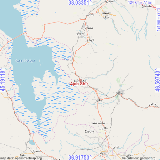
‘Ajab Shīr GPS coordinates[2]
37° 28' 39.36" North, 45° 53' 39.48" East
| Map corner | latitude | longitude |
|---|---|---|
| Upper-left | 38.03351°, | 45.19118° |
| Center: | 37.4776°, | 45.8943° |
| Lower-right: | 36.91753°, | 46.59743° |
| Map W x H: | 124.1×124.1 km | = 77.1×77.1mi |
| max Lat: | 39.6482° ⇑8.6% North |
| ‘Ajab Shīr: | 37.4776° |
| min Lat: | ⇓91.4% South 25.2919° |
| min Long | ‘Ajab Shīr | max Long |
| 44.38416° | 45.8943° | 61.9965° |
| W 4.3%⇐ | ⇒95.7% E |
Elevation
Elevation of ‘Ajab Shīr is 1297 m = 4255 ft, and this is 248 m = 814 ft above average elevation for this country.
| Max E: |
2564 m = 8412 ft | 42.9% |
| ‘Ajab Shīr | 1297 m 4255 ft | |
| Avg. | 1049 m = 3442 ft | |
Min E: |
-24 m = -79 ft | 57.1% |
See also: Iran elevation on elevation.city.
Geographical zone
‘Ajab Shīr is located in North temperate zone (between Tropic of Cancer and the Arctic Circle). Distance of this Northern Tropic circle is 1561.2 km =970.1 mi to South.| Distance of | km | miles | from ‘Ajab Shīr |
|---|---|---|---|
| North Pole | 5839.9 | 3628.7 | to North |
| Arctic Circle | 3234.1 | 2009.6 | to North |
| Tropic Cancer | 1561.2 | 970.1 | to South |
| Equator | 4167.1 | 2589.3 | to South |


Nearby cities:
15 places around ‘Ajab Shīr: (largest is in red/bold)
• Bonāb
20.9 km =13 mi,  136°
136°
• Bostānābād
92.4 km =57.4 mi,  63°
63°
• Hashtrūd
102 km =63.4 mi,  89°
89°
• Kandovān
47.1 km =29.3 mi,  41°
41°
• Mahābād
80.9 km =50.3 mi,  190°
190°
• Malekān
41.6 km =25.8 mi,  153°
153°
• Marāgheh
31.9 km =19.8 mi,  107°
107°
• Mīāndoāb
59.9 km =37.2 mi,  161°
161°
• Naqadeh
73.4 km =45.6 mi,  217°
217°
• Orūmīyeh
72.6 km =45.1 mi,  276°
276°
• Oshnavīyeh
85.6 km =53.2 mi,  235°
235°
• Oskū
52.6 km =32.7 mi,  22°
22°
• Shabestar
79.9 km =49.6 mi,  347°
347°
• Tabriz
75.5 km =46.9 mi,  27°
27°
• Āz̄arshahr
32.2 km =20 mi,  13°
13°
Sources, notices
• [Note1] Compared only with cities in Iran existing in our database
• [Src1] Map data: © OpenStreetMap contributors (CC-BY-SA)
• [Src2] Other city data from geonames.org with taken over terms of usage.
• [Src3] Geographical zone / Annual Mean Temperature by Robert A. Rohde @ Wikipedia
