Dehdasht geodata
Dehdasht (Kohgiluyeh and Boyer-Ahmad) is a seat of a second-order administrative division; located in Iran in Asia/Tehran (GMT+3.5) time zone. With population of 69,726 people, there are 95 cities with bigger population in this country. Compared to other cities in Iran, 77.8% of cities are located further ↑North; 56.9% of cities are located further →East and 66.7% of cities have higher elevation than Dehdasht. Note1


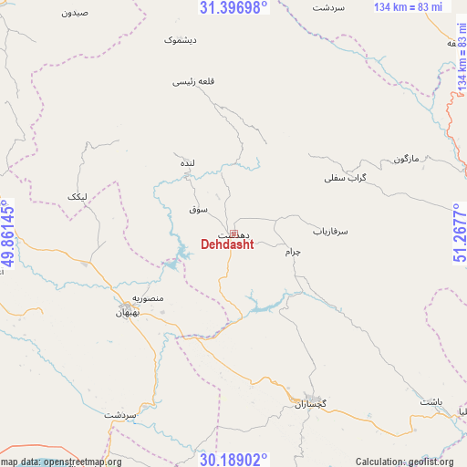
Dehdasht GPS coordinates[2]
30° 47' 41.64" North, 50° 33' 52.452" East
| Map corner | latitude | longitude |
|---|---|---|
| Upper-left | 31.39698°, | 49.86145° |
| Center: | 30.7949°, | 50.56457° |
| Lower-right: | 30.18902°, | 51.2677° |
| Map W x H: | 134.3×134.3 km | = 83.5×83.5mi |
| max Lat: | 39.6482° ⇑77.8% North |
| Dehdasht: | 30.7949° |
| min Lat: | ⇓22.2% South 25.2919° |
| min Long | Dehdasht | max Long |
| 44.38416° | 50.56457° | 61.9965° |
| W 43.1%⇐ | ⇒56.9% E |
Elevation
Elevation of Dehdasht is 806 m = 2644 ft, and this is 243 m = 797 ft below average elevation for this country.
| Max E: |
2564 m = 8412 ft | 66.7% |
| Avg. | 1049 m = 3442 ft | |
| Dehdasht | 806 m = 2644 ft | |
Min E: |
-24 m = -79 ft | 33.3% |
See also: Dehdasht elevation on elevation.city.
Geographical zone
Dehdasht is located in North temperate zone (between Tropic of Cancer and the Arctic Circle). Distance of this Northern Tropic circle is 818.2 km =508.4 mi to South.| Distance of | km | miles | from Dehdasht |
|---|---|---|---|
| North Pole | 6583 | 4090.5 | to North |
| Arctic Circle | 3977.1 | 2471.3 | to North |
| Tropic Cancer | 818.2 | 508.4 | to South |
| Equator | 3424.1 | 2127.6 | to South |


Nearby cities:
15 places around Dehdasht: (largest is in red/bold)
• Aghajari
70.8 km =44 mi,  261°
261°
• Bandar-e Deylam
91.1 km =56.6 mi,  205°
205°
• Behbahān
38 km =23.6 mi,  234°
234°
• Bāgh-e Malek
103.7 km =64.4 mi,  321°
321°
• Bāsht
74.5 km =46.3 mi,  130°
130°
• Dogonbadan
53.4 km =33.2 mi,  155°
155°
• Hendījān
102.6 km =63.8 mi, 232°
• Lordegān
83.7 km =52 mi,  17°
17°
• Līkak
46.4 km =28.8 mi,  283°
283°
• Maşīrī
110.2 km =68.5 mi,  123°
123°
• Omīdīyeh
82.5 km =51.3 mi,  267°
267°
• Rāmhormoz
106.3 km =66.1 mi,  300°
300°
• Rāmshīr
111 km =69 mi, 275°
• Sīsakht
85.4 km =53.1 mi,  84°
84°
• Yasuj
98.8 km =61.4 mi,  98°
98°
Sources, notices
• [Note1] Compared only with cities in Iran existing in our database
• [Src1] Map data: © OpenStreetMap contributors (CC-BY-SA)
• [Src2] Other city data from geonames.org with taken over terms of usage.
• [Src3] Geographical zone / Annual Mean Temperature by Robert A. Rohde @ Wikipedia
