Sīsakht geodata
Sīsakht (Kohgiluyeh and Boyer-Ahmad) is a seat of a second-order administrative division; located in Iran in Asia/Tehran (GMT+3.5) time zone. In our database, there are 232 cities with bigger population. Compared to other cities in Iran, 77.3% of cities are located further ↑North; 52.2% of cities are located further ←West and 98.2% of cities have lower elevation than Sīsakht. Note1


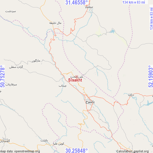
Sīsakht GPS coordinates[2]
30° 51' 50.148" North, 51° 27' 21.24" East
| Map corner | latitude | longitude |
|---|---|---|
| Upper-left | 31.46558°, | 50.75278° |
| Center: | 30.86393°, | 51.4559° |
| Lower-right: | 30.25848°, | 52.15903° |
| Map W x H: | 134.2×134.2 km | = 83.4×83.4mi |
| max Lat: | 39.6482° ⇑77.3% North |
| Sīsakht: | 30.86393° |
| min Lat: | ⇓22.7% South 25.2919° |
| min Long | Sīsakht | max Long |
| 44.38416° | 51.4559° | 61.9965° |
| W 52.2%⇐ | ⇒47.8% E |
Elevation
Elevation of Sīsakht is 2267 m = 7438 ft, and this is 1218 m = 3996 ft above average elevation for this country.
| Max E: |
2564 m = 8412 ft | 1.8% |
| Sīsakht | 2267 m 7438 ft | |
| Avg. | 1049 m = 3442 ft | |
Min E: |
-24 m = -79 ft | 98.2% |
See also: Iran elevation on elevation.city.
Geographical zone
Sīsakht is located in North temperate zone (between Tropic of Cancer and the Arctic Circle). Distance of this Northern Tropic circle is 825.8 km =513.1 mi to South.| Distance of | km | miles | from Sīsakht |
|---|---|---|---|
| North Pole | 6575.3 | 4085.7 | to North |
| Arctic Circle | 3969.4 | 2466.5 | to North |
| Tropic Cancer | 825.8 | 513.1 | to South |
| Equator | 3431.7 | 2132.4 | to South |


Nearby cities:
15 places around Sīsakht: (largest is in red/bold)
• Behbahān
119.8 km =74.4 mi,  255°
255°
• Borūjen
123.5 km =76.7 mi,  352°
352°
• Bāsht
62.8 km =39 mi,  207°
207°
• Dehdasht
85.4 km =53.1 mi, 264°
• Dehāqān
121 km =75.2 mi,  8°
8°
• Dogonbadan
84.4 km =52.4 mi,  228°
228°
• Eqlīd
118.5 km =73.6 mi,  88°
88°
• Lordegān
93.8 km =58.3 mi,  320°
320°
• Līkak
130.1 km =80.8 mi,  271°
271°
• Maşīrī
69 km =42.9 mi,  174°
174°
• Nūrābād
83.6 km =51.9 mi,  175°
175°
• Semīrom
62.4 km =38.8 mi, 9°
• Sepīdān
84 km =52.2 mi,  142°
142°
• Yasuj
25.2 km =15.7 mi,  149°
149°
• Ābādeh
118.5 km =73.6 mi,  73°
73°
Sources, notices
• [Note1] Compared only with cities in Iran existing in our database
• [Src1] Map data: © OpenStreetMap contributors (CC-BY-SA)
• [Src2] Other city data from geonames.org with taken over terms of usage.
• [Src3] Geographical zone / Annual Mean Temperature by Robert A. Rohde @ Wikipedia
