Sarāb-e Dūreh geodata
Sarāb-e Dūreh (Lorestān) is a seat of a second-order administrative division; located in Iran in Asia/Tehran (GMT+3.5) time zone. In our database, there are 232 cities with bigger population. Compared to other cities in Iran, 57.4% of cities are located further ↑North; 82.1% of cities are located further →East and 52.8% of cities have higher elevation than Sarāb-e Dūreh. Note1


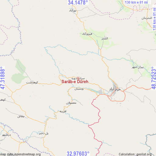
Sarāb-e Dūreh GPS coordinates[2]
33° 33' 50.04" North, 48° 1' 19.56" East
| Map corner | latitude | longitude |
|---|---|---|
| Upper-left | 34.1478°, | 47.31898° |
| Center: | 33.5639°, | 48.0221° |
| Lower-right: | 32.97603°, | 48.72523° |
| Map W x H: | 130.3×130.3 km | = 81×81mi |
| max Lat: | 39.6482° ⇑57.4% North |
| Sarāb-e Dūreh: | 33.5639° |
| min Lat: | ⇓42.6% South 25.2919° |
| min Long | Sarāb-e Dūreh | max Long |
| 44.38416° | 48.0221° | 61.9965° |
| W 17.9%⇐ | ⇒82.1% E |
Elevation
Elevation of Sarāb-e Dūreh is 1114 m = 3655 ft, and this is 65 m = 213 ft above average elevation for this country.
| Max E: |
2564 m = 8412 ft | 52.8% |
| Sarāb-e Dūreh | 1114 m 3655 ft | |
| Avg. | 1049 m = 3442 ft | |
Min E: |
-24 m = -79 ft | 47.2% |
See also: Iran elevation on elevation.city.
Geographical zone
Sarāb-e Dūreh is located in North temperate zone (between Tropic of Cancer and the Arctic Circle). Distance of this Northern Tropic circle is 1126 km =699.7 mi to South.| Distance of | km | miles | from Sarāb-e Dūreh |
|---|---|---|---|
| North Pole | 6275.1 | 3899.2 | to North |
| Arctic Circle | 3669.2 | 2279.9 | to North |
| Tropic Cancer | 1126 | 699.7 | to South |
| Equator | 3732 | 2319 | to South |


Nearby cities:
15 places around Sarāb-e Dūreh: (largest is in red/bold)
• Aleshtar
40.1 km =24.9 mi,  33°
33°
• Anūch
79.1 km =49.2 mi,  40°
40°
• Aznā
84.3 km =52.4 mi,  86°
86°
• Borūjerd
77 km =47.8 mi,  61°
61°
• Darreh Shahr
75.7 km =47 mi,  231°
231°
• Famast
66.7 km =41.4 mi, 37°
• Harsīn
88.4 km =54.9 mi,  332°
332°
• Khorramabad
32.1 km =19.9 mi,  105°
105°
• Kūhdasht
38.3 km =23.8 mi,  264°
264°
• Nahāvand
76.9 km =47.8 mi, 25°
• Nūrābād
56.8 km =35.3 mi,  355°
355°
• Poldokhtar
54.1 km =33.6 mi,  212°
212°
• Vasīān
8.5 km =5.3 mi,  162°
162°
• pamas
66.6 km =41.4 mi, 37°
• Ābdānān
84.7 km =52.6 mi,  221°
221°
Sources, notices
• [Note1] Compared only with cities in Iran existing in our database
• [Src1] Map data: © OpenStreetMap contributors (CC-BY-SA)
• [Src2] Other city data from geonames.org with taken over terms of usage.
• [Src3] Geographical zone / Annual Mean Temperature by Robert A. Rohde @ Wikipedia
