Ābdānān geodata
Ābdānān (Ilam Province) is a seat of a second-order administrative division; located in Iran in Asia/Tehran (GMT+3.5) time zone. With population of 19,360 people, there are 196 cities with bigger population in this country. Compared to other cities in Iran, 60.8% of cities are located further ↑North; 85.7% of cities are located further →East and 63.5% of cities have higher elevation than Ābdānān. Note1


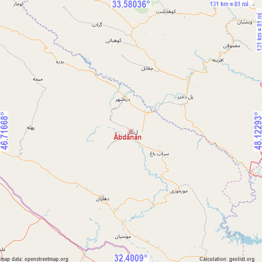
Ābdānān GPS coordinates[2]
32° 59' 33.36" North, 47° 25' 11.28" East
| Map corner | latitude | longitude |
|---|---|---|
| Upper-left | 33.58036°, | 46.71668° |
| Center: | 32.9926°, | 47.4198° |
| Lower-right: | 32.4009°, | 48.12293° |
| Map W x H: | 131.1×131.1 km | = 81.5×81.5mi |
| max Lat: | 39.6482° ⇑60.8% North |
| Ābdānān: | 32.9926° |
| min Lat: | ⇓39.2% South 25.2919° |
| min Long | Ābdānān | max Long |
| 44.38416° | 47.4198° | 61.9965° |
| W 14.3%⇐ | ⇒85.7% E |
Elevation
Elevation of Ābdānān is 889 m = 2917 ft, and this is 160 m = 525 ft below average elevation for this country.
| Max E: |
2564 m = 8412 ft | 63.5% |
| Avg. | 1049 m = 3442 ft | |
| Ābdānān | 889 m = 2917 ft | |
Min E: |
-24 m = -79 ft | 36.5% |
See also: Iran elevation on elevation.city.
Geographical zone
Ābdānān is located in North temperate zone (between Tropic of Cancer and the Arctic Circle). Distance of this Northern Tropic circle is 1062.5 km =660.2 mi to South.| Distance of | km | miles | from Ābdānān |
|---|---|---|---|
| North Pole | 6338.6 | 3938.6 | to North |
| Arctic Circle | 3732.7 | 2319.4 | to North |
| Tropic Cancer | 1062.5 | 660.2 | to South |
| Equator | 3668.4 | 2279.4 | to South |


Nearby cities:
15 places around Ābdānān: (largest is in red/bold)
• Andīmeshk
105.4 km =65.5 mi,  124°
124°
• Arakvāz-e Malekshāhī
87.9 km =54.6 mi,  299°
299°
• Darreh Shahr
17.3 km =10.7 mi,  347°
347°
• Dehlorān
36.1 km =22.4 mi,  203°
203°
• Dezful
114.6 km =71.2 mi,  126°
126°
• Khorramabad
103 km =64 mi,  57°
57°
• Kūhdasht
62.7 km =39 mi,  16°
16°
• Mehrān
117.9 km =73.3 mi,  277°
277°
• Poldokhtar
32.4 km =20.1 mi, 56°
• Sarāb-e Dūreh
84.7 km =52.6 mi,  41°
41°
• Sarābleh
117.1 km =72.8 mi,  317°
317°
• Shahrak-e Kūlūrī
121.4 km =75.4 mi, 125°
• Shūsh
117.6 km =73.1 mi,  138°
138°
• Vasīān
80.6 km =50.1 mi,  46°
46°
• Īlām
117.1 km =72.8 mi,  307°
307°
Sources, notices
• [Note1] Compared only with cities in Iran existing in our database
• [Src1] Map data: © OpenStreetMap contributors (CC-BY-SA)
• [Src2] Other city data from geonames.org with taken over terms of usage.
• [Src3] Geographical zone / Annual Mean Temperature by Robert A. Rohde @ Wikipedia
