Aleshtar geodata
Aleshtar (Lorestān) is a seat of a second-order administrative division; located in Iran in Asia/Tehran (GMT+3.5) time zone. With population of 27,701 people, there are 182 cities with bigger population in this country. Compared to other cities in Iran, 54.9% of cities are located further ↑North; 79.8% of cities are located further →East and 78.7% of cities have lower elevation than Aleshtar. Note1


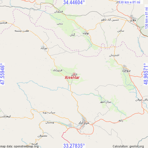
Aleshtar GPS coordinates[2]
33° 51' 51.084" North, 48° 15' 45.288" East
| Map corner | latitude | longitude |
|---|---|---|
| Upper-left | 34.44604°, | 47.55946° |
| Center: | 33.86419°, | 48.26258° |
| Lower-right: | 33.27835°, | 48.96571° |
| Map W x H: | 129.8×129.8 km | = 80.7×80.7mi |
| max Lat: | 39.6482° ⇑54.9% North |
| Aleshtar: | 33.86419° |
| min Lat: | ⇓45.1% South 25.2919° |
| min Long | Aleshtar | max Long |
| 44.38416° | 48.26258° | 61.9965° |
| W 20.2%⇐ | ⇒79.8% E |
Elevation
Elevation of Aleshtar is 1614 m = 5295 ft, and this is 565 m = 1854 ft above average elevation for this country.
| Max E: |
2564 m = 8412 ft | 21.3% |
| Aleshtar | 1614 m 5295 ft | |
| Avg. | 1049 m = 3442 ft | |
Min E: |
-24 m = -79 ft | 78.7% |
See also: Iran elevation on elevation.city.
Geographical zone
Aleshtar is located in North temperate zone (between Tropic of Cancer and the Arctic Circle). Distance of this Northern Tropic circle is 1159.4 km =720.4 mi to South.| Distance of | km | miles | from Aleshtar |
|---|---|---|---|
| North Pole | 6241.7 | 3878.4 | to North |
| Arctic Circle | 3635.8 | 2259.2 | to North |
| Tropic Cancer | 1159.4 | 720.4 | to South |
| Equator | 3765.3 | 2339.6 | to South |


Nearby cities:
15 places around Aleshtar: (largest is in red/bold)
• Anūch
39.5 km =24.5 mi,  46°
46°
• Aznā
68 km =42.3 mi,  114°
114°
• Borūjerd
45.3 km =28.1 mi,  85°
85°
• Famast
26.8 km =16.7 mi,  43°
43°
• Harsīn
77.1 km =47.9 mi,  306°
306°
• Kangāvar
76.2 km =47.3 mi,  338°
338°
• Khorramabad
42.7 km =26.5 mi,  168°
168°
• Kūhdasht
70.7 km =43.9 mi,  238°
238°
• Malāyer
70.8 km =44 mi, 46°
• Nahāvand
37.8 km =23.5 mi,  15°
15°
• Nūrābād
35.4 km =22 mi, 311°
• Sarāb-e Dūreh
40.1 km =24.9 mi,  213°
213°
• Tūyserkān
78.2 km =48.6 mi,  12°
12°
• Vasīān
46 km =28.6 mi, 205°
• pamas
26.7 km =16.6 mi, 43°
Sources, notices
• [Note1] Compared only with cities in Iran existing in our database
• [Src1] Map data: © OpenStreetMap contributors (CC-BY-SA)
• [Src2] Other city data from geonames.org with taken over terms of usage.
• [Src3] Geographical zone / Annual Mean Temperature by Robert A. Rohde @ Wikipedia
