Harsīn geodata
Harsīn (Kermānshāh) is a seat of a second-order administrative division; located in Iran in Asia/Tehran (GMT+3.5) time zone. With population of 57,647 people, there are 112 cities with bigger population in this country. Compared to other cities in Iran, 51% of cities are located further ↑North; 85.3% of cities are located further →East and 73.5% of cities have lower elevation than Harsīn. Note1


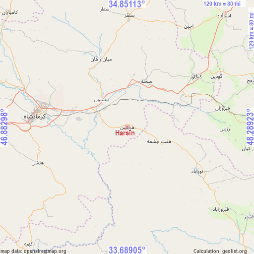
Harsīn GPS coordinates[2]
34° 16' 19.56" North, 47° 35' 9.96" East
| Map corner | latitude | longitude |
|---|---|---|
| Upper-left | 34.85113°, | 46.88298° |
| Center: | 34.2721°, | 47.5861° |
| Lower-right: | 33.68905°, | 48.28923° |
| Map W x H: | 129.2×129.2 km | = 80.3×80.3mi |
| max Lat: | 39.6482° ⇑51% North |
| Harsīn: | 34.2721° |
| min Lat: | ⇓49% South 25.2919° |
| min Long | Harsīn | max Long |
| 44.38416° | 47.5861° | 61.9965° |
| W 14.7%⇐ | ⇒85.3% E |
Elevation
Elevation of Harsīn is 1551 m = 5089 ft, and this is 502 m = 1647 ft above average elevation for this country.
| Max E: |
2564 m = 8412 ft | 26.5% |
| Harsīn | 1551 m 5089 ft | |
| Avg. | 1049 m = 3442 ft | |
Min E: |
-24 m = -79 ft | 73.5% |
See also: Harsīn elevation on elevation.city.
Geographical zone
Harsīn is located in North temperate zone (between Tropic of Cancer and the Arctic Circle). Distance of this Northern Tropic circle is 1204.8 km =748.6 mi to South.| Distance of | km | miles | from Harsīn |
|---|---|---|---|
| North Pole | 6196.4 | 3850.3 | to North |
| Arctic Circle | 3590.5 | 2231 | to North |
| Tropic Cancer | 1204.8 | 748.6 | to South |
| Equator | 3810.7 | 2367.9 | to South |


Nearby cities:
15 places around Harsīn: (largest is in red/bold)
• Aleshtar
77.1 km =47.9 mi,  126°
126°
• Asadābād
74.9 km =46.5 mi,  40°
40°
• Famast
84.7 km =52.6 mi,  107°
107°
• Kahrīz
50.3 km =31.3 mi,  284°
284°
• Kangāvar
43.3 km =26.9 mi,  53°
53°
• Kermanshah
48.1 km =29.9 mi, 275°
• Kāmyārān
83.3 km =51.8 mi,  314°
314°
• Kūhdasht
82.2 km =51.1 mi,  178°
178°
• Nahāvand
73 km =45.4 mi,  97°
97°
• Nūrābād
41.9 km =26 mi,  121°
121°
• Sarāb-e Dūreh
88.4 km =54.9 mi,  152°
152°
• Sonqor
56.7 km =35.2 mi,  1°
1°
• Tūyserkān
84.5 km =52.5 mi,  68°
68°
• pamas
84.7 km =52.6 mi, 107°
• Şaḩneh
25.2 km =15.7 mi,  22°
22°
Sources, notices
• [Note1] Compared only with cities in Iran existing in our database
• [Src1] Map data: © OpenStreetMap contributors (CC-BY-SA)
• [Src2] Other city data from geonames.org with taken over terms of usage.
• [Src3] Geographical zone / Annual Mean Temperature by Robert A. Rohde @ Wikipedia
