Kūhdasht geodata
Kūhdasht (Lorestān) is a seat of a second-order administrative division; located in Iran in Asia/Tehran (GMT+3.5) time zone. With population of 100,208 people, there are 66 cities with bigger population in this country. Compared to other cities in Iran, 57.6% of cities are located further ↑North; 84.6% of cities are located further →East and 52.4% of cities have lower elevation than Kūhdasht. Note1


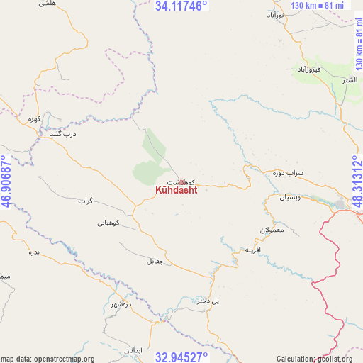
Kūhdasht GPS coordinates[2]
33° 32' 0.06" North, 47° 36' 35.964" East
| Map corner | latitude | longitude |
|---|---|---|
| Upper-left | 34.11746°, | 46.90687° |
| Center: | 33.53335°, | 47.60999° |
| Lower-right: | 32.94527°, | 48.31312° |
| Map W x H: | 130.3×130.3 km | = 81×81mi |
| max Lat: | 39.6482° ⇑57.6% North |
| Kūhdasht: | 33.53335° |
| min Lat: | ⇓42.4% South 25.2919° |
| min Long | Kūhdasht | max Long |
| 44.38416° | 47.60999° | 61.9965° |
| W 15.4%⇐ | ⇒84.6% E |
Elevation
Elevation of Kūhdasht is 1190 m = 3904 ft, and this is 141 m = 463 ft above average elevation for this country.
| Max E: |
2564 m = 8412 ft | 47.6% |
| Kūhdasht | 1190 m 3904 ft | |
| Avg. | 1049 m = 3442 ft | |
Min E: |
-24 m = -79 ft | 52.4% |
See also: Kūhdasht elevation on elevation.city.
Geographical zone
Kūhdasht is located in North temperate zone (between Tropic of Cancer and the Arctic Circle). Distance of this Northern Tropic circle is 1122.6 km =697.6 mi to South.| Distance of | km | miles | from Kūhdasht |
|---|---|---|---|
| North Pole | 6278.5 | 3901.3 | to North |
| Arctic Circle | 3672.6 | 2282 | to North |
| Tropic Cancer | 1122.6 | 697.6 | to South |
| Equator | 3728.6 | 2316.8 | to South |


Nearby cities:
15 places around Kūhdasht: (largest is in red/bold)
• Aleshtar
70.7 km =43.9 mi,  58°
58°
• Arakvāz-e Malekshāhī
95.3 km =59.2 mi,  259°
259°
• Darreh Shahr
48.2 km =30 mi,  206°
206°
• Dehlorān
98.6 km =61.3 mi,  198°
198°
• Famast
96.8 km =60.1 mi,  54°
54°
• Harsīn
82.2 km =51.1 mi,  358°
358°
• Kermanshah
100.3 km =62.3 mi,  329°
329°
• Khorramabad
69.3 km =43.1 mi,  94°
94°
• Nūrābād
68.8 km =42.8 mi,  29°
29°
• Poldokhtar
43.4 km =27 mi,  167°
167°
• Sarāb-e Dūreh
38.3 km =23.8 mi,  84°
84°
• Sarābleh
100.1 km =62.2 mi,  285°
285°
• Vasīān
41 km =25.5 mi,  96°
96°
• pamas
96.7 km =60.1 mi, 54°
• Ābdānān
62.7 km =39 mi, 196°
Sources, notices
• [Note1] Compared only with cities in Iran existing in our database
• [Src1] Map data: © OpenStreetMap contributors (CC-BY-SA)
• [Src2] Other city data from geonames.org with taken over terms of usage.
• [Src3] Geographical zone / Annual Mean Temperature by Robert A. Rohde @ Wikipedia
