Nahāvand geodata
Nahāvand (Hamadān) is a seat of a second-order administrative division; located in Iran in Asia/Tehran (GMT+3.5) time zone. With population of 76,250 people, there are 88 cities with bigger population in this country. Compared to other cities in Iran, 51.2% of cities are located further ↑North; 78% of cities are located further →East and 81.2% of cities have lower elevation than Nahāvand. Note1


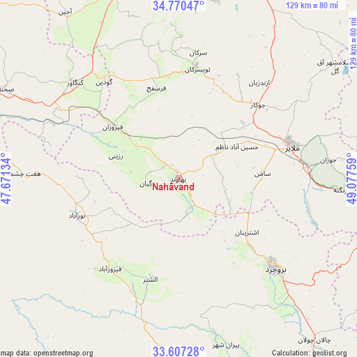
Nahāvand GPS coordinates[2]
34° 11' 27.168" North, 48° 22' 28.056" East
| Map corner | latitude | longitude |
|---|---|---|
| Upper-left | 34.77047°, | 47.67134° |
| Center: | 34.19088°, | 48.37446° |
| Lower-right: | 33.60728°, | 49.07759° |
| Map W x H: | 129.3×129.3 km | = 80.3×80.3mi |
| max Lat: | 39.6482° ⇑51.2% North |
| Nahāvand: | 34.19088° |
| min Lat: | ⇓48.8% South 25.2919° |
| min Long | Nahāvand | max Long |
| 44.38416° | 48.37446° | 61.9965° |
| W 22%⇐ | ⇒78% E |
Elevation
Elevation of Nahāvand is 1673 m = 5489 ft, and this is 624 m = 2047 ft above average elevation for this country.
| Max E: |
2564 m = 8412 ft | 18.8% |
| Nahāvand | 1673 m 5489 ft | |
| Avg. | 1049 m = 3442 ft | |
Min E: |
-24 m = -79 ft | 81.2% |
See also: Nahāvand elevation on elevation.city.
Geographical zone
Nahāvand is located in North temperate zone (between Tropic of Cancer and the Arctic Circle). Distance of this Northern Tropic circle is 1195.8 km =743 mi to South.| Distance of | km | miles | from Nahāvand |
|---|---|---|---|
| North Pole | 6205.4 | 3855.9 | to North |
| Arctic Circle | 3599.5 | 2236.6 | to North |
| Tropic Cancer | 1195.8 | 743 | to South |
| Equator | 3801.7 | 2362.3 | to South |


Nearby cities:
15 places around Nahāvand: (largest is in red/bold)
• Aleshtar
37.8 km =23.5 mi,  195°
195°
• Anūch
20.5 km =12.7 mi,  116°
116°
• Asadābād
69.8 km =43.4 mi,  340°
340°
• Borūjerd
47.7 km =29.6 mi,  133°
133°
• Famast
18.7 km =11.6 mi,  154°
154°
• Hamadān
68.8 km =42.8 mi,  10°
10°
• Harsīn
73 km =45.4 mi,  277°
277°
• Kangāvar
51.2 km =31.8 mi,  312°
312°
• Malāyer
42.9 km =26.7 mi,  73°
73°
• Nūrābād
39.2 km =24.4 mi,  250°
250°
• Pasragad Branch
65.9 km =40.9 mi, 7°
• Tūyserkān
40.5 km =25.2 mi, 8°
• pamas
18.8 km =11.7 mi, 154°
• Āzādshahr
69 km =42.9 mi,  15°
15°
• Şaḩneh
70.6 km =43.9 mi,  297°
297°
Sources, notices
• [Note1] Compared only with cities in Iran existing in our database
• [Src1] Map data: © OpenStreetMap contributors (CC-BY-SA)
• [Src2] Other city data from geonames.org with taken over terms of usage.
• [Src3] Geographical zone / Annual Mean Temperature by Robert A. Rohde @ Wikipedia
