Anūch geodata
Anūch (Hamadān) is a populated place; located in Iran in Asia/Tehran (GMT+3.5) time zone. With population of 1,833 people, there are 222 cities with bigger population in this country. Compared to other cities in Iran, 51.9% of cities are located further ↑North; 75.1% of cities are located further →East and 92.5% of cities have lower elevation than Anūch. Note1


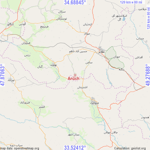
Anūch GPS coordinates[2]
34° 6' 29.844" North, 48° 34' 25.5" East
| Map corner | latitude | longitude |
|---|---|---|
| Upper-left | 34.68845°, | 47.87063° |
| Center: | 34.10829°, | 48.57375° |
| Lower-right: | 33.52412°, | 49.27688° |
| Map W x H: | 129.5×129.5 km | = 80.5×80.5mi |
| max Lat: | 39.6482° ⇑51.9% North |
| Anūch: | 34.10829° |
| min Lat: | ⇓48.1% South 25.2919° |
| min Long | Anūch | max Long |
| 44.38416° | 48.57375° | 61.9965° |
| W 24.9%⇐ | ⇒75.1% E |
Elevation
Elevation of Anūch is 1935 m = 6348 ft, and this is 886 m = 2907 ft above average elevation for this country.
| Max E: |
2564 m = 8412 ft | 7.5% |
| Anūch | 1935 m 6348 ft | |
| Avg. | 1049 m = 3442 ft | |
Min E: |
-24 m = -79 ft | 92.5% |
See also: Iran elevation on elevation.city.
Geographical zone
Anūch is located in North temperate zone (between Tropic of Cancer and the Arctic Circle). Distance of this Northern Tropic circle is 1186.6 km =737.3 mi to South.| Distance of | km | miles | from Anūch |
|---|---|---|---|
| North Pole | 6214.6 | 3861.6 | to North |
| Arctic Circle | 3608.7 | 2242.3 | to North |
| Tropic Cancer | 1186.6 | 737.3 | to South |
| Equator | 3792.5 | 2356.5 | to South |


Nearby cities:
15 places around Anūch: (largest is in red/bold)
• Aleshtar
39.5 km =24.5 mi,  226°
226°
• Aznā
64.5 km =40.1 mi,  149°
149°
• Borūjerd
28.6 km =17.8 mi, 145°
• Famast
12.8 km =8 mi, 233°
• Hamadān
77 km =47.8 mi,  355°
355°
• Kangāvar
71.1 km =44.2 mi,  308°
308°
• Khondāb
64.4 km =40 mi,  60°
60°
• Khorramabad
71.9 km =44.7 mi,  196°
196°
• Malāyer
31.3 km =19.4 mi,  46°
46°
• Nahāvand
20.5 km =12.7 mi,  296°
296°
• Nūrābād
55.5 km =34.5 mi,  265°
265°
• Pasragad Branch
75 km =46.6 mi,  352°
352°
• Tūyserkān
50.7 km =31.5 mi, 346°
• pamas
12.9 km =8 mi, 232°
• Āzādshahr
75.9 km =47.2 mi, 359°
Sources, notices
• [Note1] Compared only with cities in Iran existing in our database
• [Src1] Map data: © OpenStreetMap contributors (CC-BY-SA)
• [Src2] Other city data from geonames.org with taken over terms of usage.
• [Src3] Geographical zone / Annual Mean Temperature by Robert A. Rohde @ Wikipedia
