Qom geodata
Qom is a seat of a first-order administrative division; located in Iran in Asia/Tehran (GMT+3.5) time zone. With population of 900,000 people, there are 6 cities with bigger population in this country. Compared to other cities in Iran, 52.6% of cities are located further ↓South; 53.7% of cities are located further →East and 61.7% of cities have higher elevation than Qom. Note1


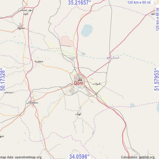
Qom GPS coordinates[2]
34° 38' 24.36" North, 50° 52' 35.04" East
| Map corner | latitude | longitude |
|---|---|---|
| Upper-left | 35.21657°, | 50.17328° |
| Center: | 34.6401°, | 50.8764° |
| Lower-right: | 34.0596°, | 51.57953° |
| Map W x H: | 128.6×128.6 km | = 79.9×79.9mi |
| max Lat: | 39.6482° ⇑47.4% North |
| Qom: | 34.6401° |
| min Lat: | ⇓52.6% South 25.2919° |
| min Long | Qom | max Long |
| 44.38416° | 50.8764° | 61.9965° |
| W 46.3%⇐ | ⇒53.7% E |
Elevation
Elevation of Qom is 935 m = 3068 ft, and this is 114 m = 374 ft below average elevation for this country.
| Max E: |
2564 m = 8412 ft | 61.7% |
| Avg. | 1049 m = 3442 ft | |
| Qom | 935 m = 3068 ft | |
Min E: |
-24 m = -79 ft | 38.3% |
See also: Qom elevation on elevation.city.
Geographical zone
Qom is located in North temperate zone (between Tropic of Cancer and the Arctic Circle). Distance of this Northern Tropic circle is 1245.7 km =774 mi to South.| Distance of | km | miles | from Qom |
|---|---|---|---|
| North Pole | 6155.4 | 3824.8 | to North |
| Arctic Circle | 3549.6 | 2205.6 | to North |
| Tropic Cancer | 1245.7 | 774 | to South |
| Equator | 3851.6 | 2393.3 | to South |


Nearby cities:
15 places around Qom: (largest is in red/bold)
• Delījān
74.4 km =46.2 mi,  193°
193°
• Eqbālīyeh
95 km =59 mi,  39°
39°
• Eslāmshahr
106.5 km =66.2 mi,  17°
17°
• Kāshān
88.3 km =54.9 mi,  144°
144°
• Maḩallāt
89.9 km =55.9 mi,  205°
205°
• Māmūnīyeh
81.6 km =50.7 mi,  335°
335°
• Pīshvā
107.3 km =66.7 mi,  46°
46°
• Qarchak
108.3 km =67.3 mi, 35°
• Robāţ Karīm
95.8 km =59.5 mi,  11°
11°
• Shahrak-e Emām Ḩasan
103.5 km =64.3 mi, 24°
• Sāveh
63.6 km =39.5 mi,  311°
311°
• Tafresh
78.9 km =49 mi,  274°
274°
• Varāmīn
103.4 km =64.2 mi, 42°
• Ārān Bīdgol
85.4 km =53.1 mi, 139°
• Āshtīān
80.7 km =50.1 mi,  260°
260°
Sources, notices
• [Note1] Compared only with cities in Iran existing in our database
• [Src1] Map data: © OpenStreetMap contributors (CC-BY-SA)
• [Src2] Other city data from geonames.org with taken over terms of usage.
• [Src3] Geographical zone / Annual Mean Temperature by Robert A. Rohde @ Wikipedia
