Āshtīān geodata
Āshtīān (Markazi) is a seat of a second-order administrative division; located in Iran in Asia/Tehran (GMT+3.5) time zone. In our database, there are 232 cities with bigger population. Compared to other cities in Iran, 51.9% of cities are located further ↓South; 62.8% of cities are located further →East and 95.5% of cities have lower elevation than Āshtīān. Note1


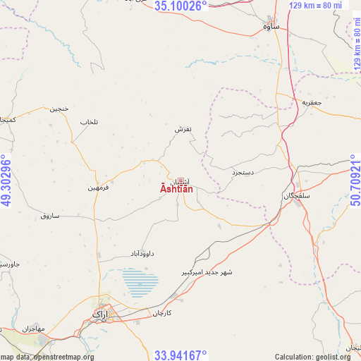
Āshtīān GPS coordinates[2]
34° 31' 22.728" North, 50° 0' 21.888" East
| Map corner | latitude | longitude |
|---|---|---|
| Upper-left | 35.10026°, | 49.30296° |
| Center: | 34.52298°, | 50.00608° |
| Lower-right: | 33.94167°, | 50.70921° |
| Map W x H: | 128.8×128.8 km | = 80×80mi |
| max Lat: | 39.6482° ⇑48.1% North |
| Āshtīān: | 34.52298° |
| min Lat: | ⇓51.9% South 25.2919° |
| min Long | Āshtīān | max Long |
| 44.38416° | 50.00608° | 61.9965° |
| W 37.2%⇐ | ⇒62.8% E |
Elevation
Elevation of Āshtīān is 2073 m = 6801 ft, and this is 1024 m = 3360 ft above average elevation for this country.
| Max E: |
2564 m = 8412 ft | 4.5% |
| Āshtīān | 2073 m 6801 ft | |
| Avg. | 1049 m = 3442 ft | |
Min E: |
-24 m = -79 ft | 95.5% |
See also: Iran elevation on elevation.city.
Geographical zone
Āshtīān is located in North temperate zone (between Tropic of Cancer and the Arctic Circle). Distance of this Northern Tropic circle is 1232.7 km =766 mi to South.| Distance of | km | miles | from Āshtīān |
|---|---|---|---|
| North Pole | 6168.5 | 3832.9 | to North |
| Arctic Circle | 3562.6 | 2213.7 | to North |
| Tropic Cancer | 1232.7 | 766 | to South |
| Equator | 3838.6 | 2385.2 | to South |


Nearby cities:
15 places around Āshtīān: (largest is in red/bold)
• Arāk
55.4 km =34.4 mi,  210°
210°
• Delījān
85.9 km =53.4 mi,  133°
133°
• Farmahīn
29.6 km =18.4 mi,  265°
265°
• Fāmenīn
115 km =71.5 mi,  304°
304°
• Golpāyegān
121.7 km =75.6 mi,  167°
167°
• Khomeyn
98.5 km =61.2 mi,  176°
176°
• Khondāb
76.7 km =47.7 mi,  259°
259°
• Komījān
66 km =41 mi,  289°
289°
• Malāyer
111.4 km =69.2 mi, 257°
• Maḩallāt
79.5 km =49.4 mi,  148°
148°
• Māmūnīyeh
97.9 km =60.8 mi,  27°
27°
• Qom
80.7 km =50.1 mi,  80°
80°
• Shāzand
85.8 km =53.3 mi,  219°
219°
• Sāveh
64 km =39.8 mi, 30°
• Tafresh
18.9 km =11.7 mi,  2°
2°
Sources, notices
• [Note1] Compared only with cities in Iran existing in our database
• [Src1] Map data: © OpenStreetMap contributors (CC-BY-SA)
• [Src2] Other city data from geonames.org with taken over terms of usage.
• [Src3] Geographical zone / Annual Mean Temperature by Robert A. Rohde @ Wikipedia
