Ārān Bīdgol geodata
Ārān Bīdgol (Isfahan) is a seat of a second-order administrative division; located in Iran in Asia/Tehran (GMT+3.5) time zone. In our database, there are 232 cities with bigger population. Compared to other cities in Iran, 52.6% of cities are located further ↑North; 52.4% of cities are located further ←West and 63% of cities have higher elevation than Ārān Bīdgol. Note1


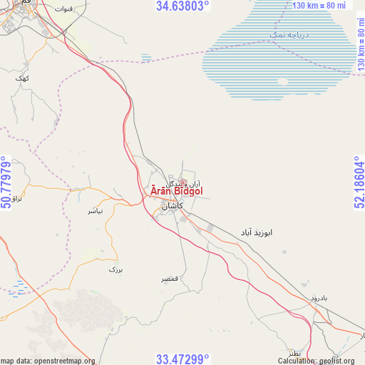
Ārān Bīdgol GPS coordinates[2]
34° 3' 27.036" North, 51° 28' 58.476" East
| Map corner | latitude | longitude |
|---|---|---|
| Upper-left | 34.63803°, | 50.77979° |
| Center: | 34.05751°, | 51.48291° |
| Lower-right: | 33.47299°, | 52.18604° |
| Map W x H: | 129.5×129.5 km | = 80.5×80.5mi |
| max Lat: | 39.6482° ⇑52.6% North |
| Ārān Bīdgol: | 34.05751° |
| min Lat: | ⇓47.4% South 25.2919° |
| min Long | Ārān Bīdgol | max Long |
| 44.38416° | 51.48291° | 61.9965° |
| W 52.4%⇐ | ⇒47.6% E |
Elevation
Elevation of Ārān Bīdgol is 909 m = 2982 ft, and this is 140 m = 459 ft below average elevation for this country.
| Max E: |
2564 m = 8412 ft | 63% |
| Avg. | 1049 m = 3442 ft | |
| Ārān Bīdgol | 909 m = 2982 ft | |
Min E: |
-24 m = -79 ft | 37% |
See also: Iran elevation on elevation.city.
Geographical zone
Ārān Bīdgol is located in North temperate zone (between Tropic of Cancer and the Arctic Circle). Distance of this Northern Tropic circle is 1180.9 km =733.8 mi to South.| Distance of | km | miles | from Ārān Bīdgol |
|---|---|---|---|
| North Pole | 6220.2 | 3865.1 | to North |
| Arctic Circle | 3614.3 | 2245.8 | to North |
| Tropic Cancer | 1180.9 | 733.8 | to South |
| Equator | 3786.8 | 2353 | to South |


Nearby cities:
15 places around Ārān Bīdgol: (largest is in red/bold)
• Ardestān
111.6 km =69.3 mi,  132°
132°
• Delījān
74 km =46 mi,  264°
264°
• Dowlatābād
141.2 km =87.7 mi,  171°
171°
• Eqbālīyeh
138.5 km =86.1 mi,  2°
2°
• Golpāyegān
129.2 km =80.3 mi,  238°
238°
• Khomeyn
137.7 km =85.6 mi,  250°
250°
• Khvānsār
142.7 km =88.7 mi,  229°
229°
• Kāshān
7.7 km =4.8 mi,  209°
209°
• Maḩallāt
96.3 km =59.8 mi, 260°
• Naţanz
72.9 km =45.3 mi,  146°
146°
• Pīshvā
140.8 km =87.5 mi,  9°
9°
• Qom
85.4 km =53.1 mi,  319°
319°
• Shāhīn Shahr
133.5 km =83 mi,  177°
177°
• Varāmīn
141.6 km =88 mi, 6°
• Āshtīān
145.2 km =90.2 mi,  290°
290°
Sources, notices
• [Note1] Compared only with cities in Iran existing in our database
• [Src1] Map data: © OpenStreetMap contributors (CC-BY-SA)
• [Src2] Other city data from geonames.org with taken over terms of usage.
• [Src3] Geographical zone / Annual Mean Temperature by Robert A. Rohde @ Wikipedia
