Tafresh geodata
Tafresh (Markazi) is a seat of a second-order administrative division; located in Iran in Asia/Tehran (GMT+3.5) time zone. With population of 14,399 people, there are 202 cities with bigger population in this country. Compared to other cities in Iran, 52.8% of cities are located further ↓South; 62.4% of cities are located further →East and 91.6% of cities have lower elevation than Tafresh. Note1


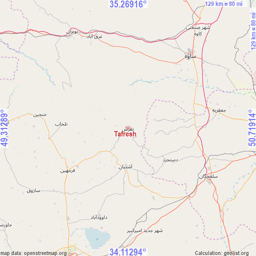
Tafresh GPS coordinates[2]
34° 41' 35.052" North, 50° 0' 57.636" East
| Map corner | latitude | longitude |
|---|---|---|
| Upper-left | 35.26916°, | 49.31289° |
| Center: | 34.69307°, | 50.01601° |
| Lower-right: | 34.11294°, | 50.71914° |
| Map W x H: | 128.6×128.6 km | = 79.9×79.9mi |
| max Lat: | 39.6482° ⇑47.2% North |
| Tafresh: | 34.69307° |
| min Lat: | ⇓52.8% South 25.2919° |
| min Long | Tafresh | max Long |
| 44.38416° | 50.01601° | 61.9965° |
| W 37.6%⇐ | ⇒62.4% E |
Elevation
Elevation of Tafresh is 1910 m = 6266 ft, and this is 861 m = 2825 ft above average elevation for this country.
| Max E: |
2564 m = 8412 ft | 8.4% |
| Tafresh | 1910 m 6266 ft | |
| Avg. | 1049 m = 3442 ft | |
Min E: |
-24 m = -79 ft | 91.6% |
See also: Iran elevation on elevation.city.
Geographical zone
Tafresh is located in North temperate zone (between Tropic of Cancer and the Arctic Circle). Distance of this Northern Tropic circle is 1251.6 km =777.7 mi to South.| Distance of | km | miles | from Tafresh |
|---|---|---|---|
| North Pole | 6149.6 | 3821.2 | to North |
| Arctic Circle | 3543.7 | 2202 | to North |
| Tropic Cancer | 1251.6 | 777.7 | to South |
| Equator | 3857.5 | 2396.9 | to South |


Nearby cities:
15 places around Tafresh: (largest is in red/bold)
• Arāk
72.6 km =45.1 mi,  203°
203°
• Delījān
99.3 km =61.7 mi,  141°
141°
• Farmahīn
36.9 km =22.9 mi,  235°
235°
• Fāmenīn
106.1 km =65.9 mi,  296°
296°
• Khomeyn
117.4 km =72.9 mi,  177°
177°
• Khondāb
83.2 km =51.7 mi,  246°
246°
• Komījān
63.1 km =39.2 mi,  272°
272°
• Malāyer
117.8 km =73.2 mi, 248°
• Maḩallāt
95.8 km =59.5 mi,  155°
155°
• Māmūnīyeh
81.1 km =50.4 mi,  32°
32°
• Qom
78.9 km =49 mi,  94°
94°
• Razan
118.1 km =73.4 mi,  310°
310°
• Shāzand
101.5 km =63.1 mi,  213°
213°
• Sāveh
47.9 km =29.8 mi,  40°
40°
• Āshtīān
18.9 km =11.7 mi, 182°
Sources, notices
• [Note1] Compared only with cities in Iran existing in our database
• [Src1] Map data: © OpenStreetMap contributors (CC-BY-SA)
• [Src2] Other city data from geonames.org with taken over terms of usage.
• [Src3] Geographical zone / Annual Mean Temperature by Robert A. Rohde @ Wikipedia
