Kāshān geodata
Kāshān (Isfahan) is a seat of a second-order administrative division; located in Iran in Asia/Tehran (GMT+3.5) time zone. In our database, there are 232 cities with bigger population. Compared to other cities in Iran, 53.5% of cities are located further ↑North; 51.7% of cities are located further ←West and 61.5% of cities have higher elevation than Kāshān. Note1


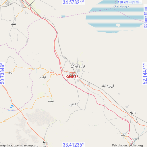
Kāshān GPS coordinates[2]
33° 59' 50.208" North, 51° 26' 29.688" East
| Map corner | latitude | longitude |
|---|---|---|
| Upper-left | 34.57821°, | 50.73846° |
| Center: | 33.99728°, | 51.44158° |
| Lower-right: | 33.41235°, | 52.14471° |
| Map W x H: | 129.6×129.6 km | = 80.5×80.5mi |
| max Lat: | 39.6482° ⇑53.5% North |
| Kāshān: | 33.99728° |
| min Lat: | ⇓46.5% South 25.2919° |
| min Long | Kāshān | max Long |
| 44.38416° | 51.44158° | 61.9965° |
| W 51.7%⇐ | ⇒48.3% E |
Elevation
Elevation of Kāshān is 936 m = 3071 ft, and this is 113 m = 371 ft below average elevation for this country.
| Max E: |
2564 m = 8412 ft | 61.5% |
| Avg. | 1049 m = 3442 ft | |
| Kāshān | 936 m = 3071 ft | |
Min E: |
-24 m = -79 ft | 38.5% |
See also: Iran elevation on elevation.city.
Geographical zone
Kāshān is located in North temperate zone (between Tropic of Cancer and the Arctic Circle). Distance of this Northern Tropic circle is 1174.2 km =729.6 mi to South.| Distance of | km | miles | from Kāshān |
|---|---|---|---|
| North Pole | 6226.9 | 3869.2 | to North |
| Arctic Circle | 3621 | 2250 | to North |
| Tropic Cancer | 1174.2 | 729.6 | to South |
| Equator | 3780.1 | 2348.8 | to South |


Nearby cities:
15 places around Kāshān: (largest is in red/bold)
• Ardestān
110.2 km =68.5 mi,  128°
128°
• Delījān
69.9 km =43.4 mi,  269°
269°
• Dowlatābād
135.2 km =84 mi,  169°
169°
• Eqbālīyeh
145.3 km =90.3 mi,  3°
3°
• Golpāyegān
122.6 km =76.2 mi,  240°
240°
• Khomeyn
131.9 km =82 mi,  252°
252°
• Khomeynī Shahr
146.1 km =90.8 mi,  176°
176°
• Khvānsār
135.4 km =84.1 mi,  230°
230°
• Maḩallāt
91.7 km =57 mi,  263°
263°
• Naţanz
69.7 km =43.3 mi,  140°
140°
• Qom
88.3 km =54.9 mi,  324°
324°
• Shāhīn Shahr
127.1 km =79 mi, 175°
• Tīrān
146.4 km =91 mi,  190°
190°
• Ārān Bīdgol
7.7 km =4.8 mi,  29°
29°
• Āshtīān
144.3 km =89.7 mi,  293°
293°
Sources, notices
• [Note1] Compared only with cities in Iran existing in our database
• [Src1] Map data: © OpenStreetMap contributors (CC-BY-SA)
• [Src2] Other city data from geonames.org with taken over terms of usage.
• [Src3] Geographical zone / Annual Mean Temperature by Robert A. Rohde @ Wikipedia
