Delījān geodata
Delījān (Markazi) is a seat of a second-order administrative division; located in Iran in Asia/Tehran (GMT+3.5) time zone. With population of 33,508 people, there are 170 cities with bigger population in this country. Compared to other cities in Iran, 53.7% of cities are located further ↑North; 55.6% of cities are located further →East and 71.7% of cities have lower elevation than Delījān. Note1


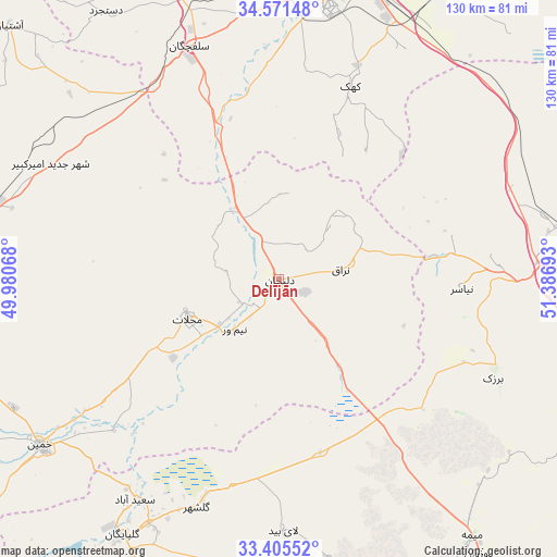
Delījān GPS coordinates[2]
33° 59' 25.8" North, 50° 41' 1.68" East
| Map corner | latitude | longitude |
|---|---|---|
| Upper-left | 34.57148°, | 49.98068° |
| Center: | 33.9905°, | 50.6838° |
| Lower-right: | 33.40552°, | 51.38693° |
| Map W x H: | 129.6×129.6 km | = 80.5×80.5mi |
| max Lat: | 39.6482° ⇑53.7% North |
| Delījān: | 33.9905° |
| min Lat: | ⇓46.3% South 25.2919° |
| min Long | Delījān | max Long |
| 44.38416° | 50.6838° | 61.9965° |
| W 44.4%⇐ | ⇒55.6% E |
Elevation
Elevation of Delījān is 1522 m = 4993 ft, and this is 473 m = 1552 ft above average elevation for this country.
| Max E: |
2564 m = 8412 ft | 28.3% |
| Delījān | 1522 m 4993 ft | |
| Avg. | 1049 m = 3442 ft | |
Min E: |
-24 m = -79 ft | 71.7% |
See also: Iran elevation on elevation.city.
Geographical zone
Delījān is located in North temperate zone (between Tropic of Cancer and the Arctic Circle). Distance of this Northern Tropic circle is 1173.5 km =729.2 mi to South.| Distance of | km | miles | from Delījān |
|---|---|---|---|
| North Pole | 6227.7 | 3869.7 | to North |
| Arctic Circle | 3621.8 | 2250.5 | to North |
| Tropic Cancer | 1173.5 | 729.2 | to South |
| Equator | 3779.4 | 2348.4 | to South |


Nearby cities:
15 places around Delījān: (largest is in red/bold)
• Alīgūdarz
112.6 km =70 mi,  234°
234°
• Arāk
91.6 km =56.9 mi,  277°
277°
• Dārān
114.2 km =71 mi,  192°
192°
• Farmahīn
108.1 km =67.2 mi,  301°
301°
• Golpāyegān
70 km =43.5 mi,  211°
211°
• Khomeyn
68.1 km =42.3 mi, 234°
• Khvānsār
92.2 km =57.3 mi,  201°
201°
• Kāshān
69.9 km =43.4 mi,  89°
89°
• Maḩallāt
23 km =14.3 mi,  247°
247°
• Qom
74.4 km =46.2 mi,  13°
13°
• Shāzand
118 km =73.3 mi,  266°
266°
• Sāveh
118.5 km =73.6 mi,  345°
345°
• Tafresh
99.3 km =61.7 mi,  321°
321°
• Ārān Bīdgol
74 km =46 mi,  84°
84°
• Āshtīān
85.9 km =53.4 mi,  313°
313°
Sources, notices
• [Note1] Compared only with cities in Iran existing in our database
• [Src1] Map data: © OpenStreetMap contributors (CC-BY-SA)
• [Src2] Other city data from geonames.org with taken over terms of usage.
• [Src3] Geographical zone / Annual Mean Temperature by Robert A. Rohde @ Wikipedia
