Joghtāy geodata
Joghtāy (Razavi Khorasan) is a seat of a second-order administrative division; located in Iran in Asia/Tehran (GMT+3.5) time zone. In our database, there are 232 cities with bigger population. Compared to other cities in Iran, 75.7% of cities are located further ↓South; 83.9% of cities are located further ←West and 62.4% of cities have lower elevation than Joghtāy. Note1


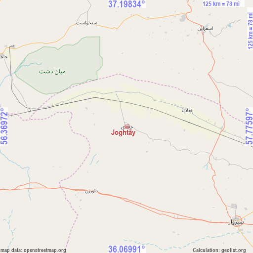
Joghtāy GPS coordinates[2]
36° 38' 10.284" North, 57° 4' 22.224" East
| Map corner | latitude | longitude |
|---|---|---|
| Upper-left | 37.19834°, | 56.36972° |
| Center: | 36.63619°, | 57.07284° |
| Lower-right: | 36.06991°, | 57.77597° |
| Map W x H: | 125.5×125.5 km | = 78×78mi |
| max Lat: | 39.6482° ⇑24.3% North |
| Joghtāy: | 36.63619° |
| min Lat: | ⇓75.7% South 25.2919° |
| min Long | Joghtāy | max Long |
| 44.38416° | 57.07284° | 61.9965° |
| W 83.9%⇐ | ⇒16.1% E |
Elevation
Elevation of Joghtāy is 1360 m = 4462 ft, and this is 311 m = 1020 ft above average elevation for this country.
| Max E: |
2564 m = 8412 ft | 37.6% |
| Joghtāy | 1360 m 4462 ft | |
| Avg. | 1049 m = 3442 ft | |
Min E: |
-24 m = -79 ft | 62.4% |
See also: Iran elevation on elevation.city.
Geographical zone
Joghtāy is located in North temperate zone (between Tropic of Cancer and the Arctic Circle). Distance of this Northern Tropic circle is 1467.6 km =911.9 mi to South.| Distance of | km | miles | from Joghtāy |
|---|---|---|---|
| North Pole | 5933.5 | 3686.9 | to North |
| Arctic Circle | 3327.6 | 2067.7 | to North |
| Tropic Cancer | 1467.6 | 911.9 | to South |
| Equator | 4073.6 | 2531.2 | to South |


Nearby cities:
15 places around Joghtāy: (largest is in red/bold)
• Bojnūrd
96 km =59.7 mi,  13°
13°
• Bozghān
140.8 km =87.5 mi,  106°
106°
• Esfarāyen
62.5 km =38.8 mi,  38°
38°
• Fārūj
121.5 km =75.5 mi,  56°
56°
• Garmeh
79.9 km =49.6 mi,  299°
299°
• Gālīkesh
161.9 km =100.6 mi, 295°
• Jājarm
70.9 km =44.1 mi, 299°
• Kalāleh
162.8 km =101.2 mi, 300°
• Neqāb
32.1 km =19.9 mi,  75°
75°
• Neyshābūr
161.2 km =100.2 mi, 106°
• Qūchān
138.1 km =85.8 mi,  67°
67°
• Sabzevar
72 km =44.7 mi,  130°
130°
• Shīrvān
113.7 km =70.6 mi, 41°
• Solţānābād
90.1 km =56 mi, 106°
• Āshkhāneh
103.8 km =64.5 mi,  352°
352°
Sources, notices
• [Note1] Compared only with cities in Iran existing in our database
• [Src1] Map data: © OpenStreetMap contributors (CC-BY-SA)
• [Src2] Other city data from geonames.org with taken over terms of usage.
• [Src3] Geographical zone / Annual Mean Temperature by Robert A. Rohde @ Wikipedia
