Bozghān geodata
Bozghān (Razavi Khorasan) is a seat of a second-order administrative division; located in Iran in Asia/Tehran (GMT+3.5) time zone. In our database, there are 232 cities with bigger population. Compared to other cities in Iran, 71.9% of cities are located further ↓South; 90.5% of cities are located further ←West and 50.1% of cities have higher elevation than Bozghān. Note1


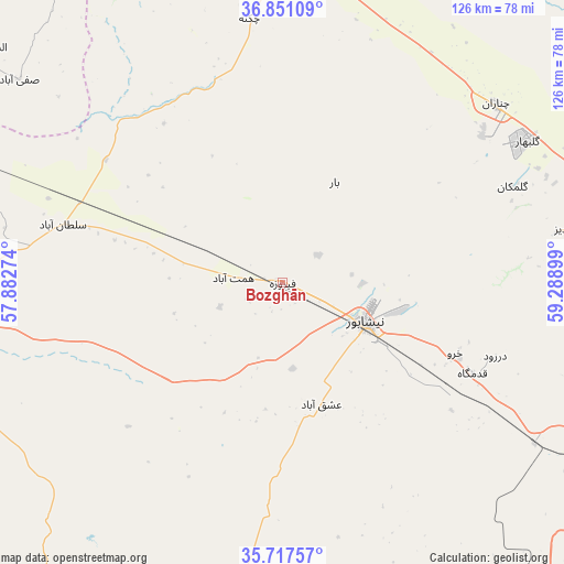
Bozghān GPS coordinates[2]
36° 17' 11.004" North, 58° 35' 9.096" East
| Map corner | latitude | longitude |
|---|---|---|
| Upper-left | 36.85109°, | 57.88274° |
| Center: | 36.28639°, | 58.58586° |
| Lower-right: | 35.71757°, | 59.28899° |
| Map W x H: | 126×126 km | = 78.3×78.3mi |
| max Lat: | 39.6482° ⇑28.1% North |
| Bozghān: | 36.28639° |
| min Lat: | ⇓71.9% South 25.2919° |
| min Long | Bozghān | max Long |
| 44.38416° | 58.58586° | 61.9965° |
| W 90.5%⇐ | ⇒9.5% E |
Elevation
Elevation of Bozghān is 1168 m = 3832 ft, and this is 119 m = 390 ft above average elevation for this country.
| Max E: |
2564 m = 8412 ft | 50.1% |
| Bozghān | 1168 m 3832 ft | |
| Avg. | 1049 m = 3442 ft | |
Min E: |
-24 m = -79 ft | 49.9% |
See also: Iran elevation on elevation.city.
Geographical zone
Bozghān is located in North temperate zone (between Tropic of Cancer and the Arctic Circle). Distance of this Northern Tropic circle is 1428.7 km =887.8 mi to South.| Distance of | km | miles | from Bozghān |
|---|---|---|---|
| North Pole | 5972.4 | 3711.1 | to North |
| Arctic Circle | 3366.5 | 2091.8 | to North |
| Tropic Cancer | 1428.7 | 887.8 | to South |
| Equator | 4034.7 | 2507 | to South |


Nearby cities:
15 places around Bozghān: (largest is in red/bold)
• Bardaskan
126.7 km =78.7 mi,  205°
205°
• Chenārān
62.3 km =38.7 mi,  50°
50°
• Esfarāyen
130.1 km =80.8 mi,  312°
312°
• Farīmān
130.7 km =81.2 mi,  119°
119°
• Fārūj
110 km =68.4 mi,  342°
342°
• Khalīlābād
117.9 km =73.3 mi,  193°
193°
• Kāshmar
117 km =72.7 mi, 185°
• Mashhad
88.1 km =54.7 mi,  87°
87°
• Neqāb
114.1 km =70.9 mi,  294°
294°
• Neyshābūr
20.5 km =12.7 mi,  113°
113°
• Qūchān
91.4 km =56.8 mi,  355°
355°
• Sabzevar
81.5 km =50.6 mi,  264°
264°
• Solţānābād
50.7 km =31.5 mi,  284°
284°
• Torbat-e Ḩeydarīyeh
126.2 km =78.4 mi,  153°
153°
• Ţorqabeh
70.6 km =43.9 mi, 87°
Sources, notices
• [Note1] Compared only with cities in Iran existing in our database
• [Src1] Map data: © OpenStreetMap contributors (CC-BY-SA)
• [Src2] Other city data from geonames.org with taken over terms of usage.
• [Src3] Geographical zone / Annual Mean Temperature by Robert A. Rohde @ Wikipedia
