Neyshābūr geodata
Neyshābūr (Razavi Khorasan) is a seat of a second-order administrative division; located in Iran in Asia/Tehran (GMT+3.5) time zone. With population of 220,929 people, there are 34 cities with bigger population in this country. Compared to other cities in Iran, 71.2% of cities are located further ↓South; 91.4% of cities are located further ←West and 52.6% of cities have lower elevation than Neyshābūr. Note1


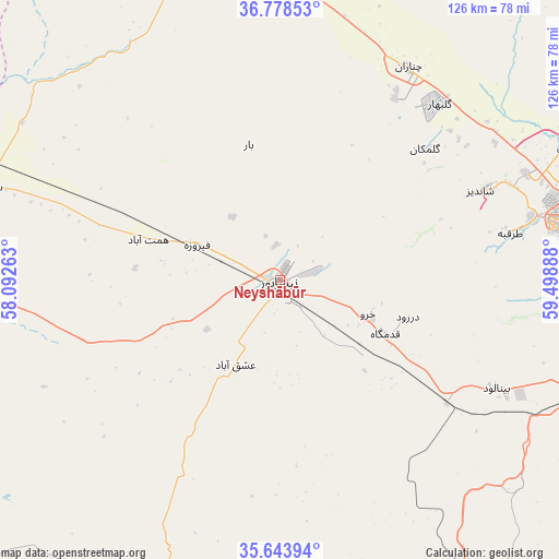
Neyshābūr GPS coordinates[2]
36° 12' 47.844" North, 58° 47' 44.7" East
| Map corner | latitude | longitude |
|---|---|---|
| Upper-left | 36.77853°, | 58.09263° |
| Center: | 36.21329°, | 58.79575° |
| Lower-right: | 35.64394°, | 59.49888° |
| Map W x H: | 126.2×126.2 km | = 78.4×78.4mi |
| max Lat: | 39.6482° ⇑28.8% North |
| Neyshābūr: | 36.21329° |
| min Lat: | ⇓71.2% South 25.2919° |
| min Long | Neyshābūr | max Long |
| 44.38416° | 58.79575° | 61.9965° |
| W 91.4%⇐ | ⇒8.6% E |
Elevation
Elevation of Neyshābūr is 1199 m = 3934 ft, and this is 150 m = 492 ft above average elevation for this country.
| Max E: |
2564 m = 8412 ft | 47.4% |
| Neyshābūr | 1199 m 3934 ft | |
| Avg. | 1049 m = 3442 ft | |
Min E: |
-24 m = -79 ft | 52.6% |
See also: Neyshābūr elevation on elevation.city.
Geographical zone
Neyshābūr is located in North temperate zone (between Tropic of Cancer and the Arctic Circle). Distance of this Northern Tropic circle is 1420.6 km =882.7 mi to South.| Distance of | km | miles | from Neyshābūr |
|---|---|---|---|
| North Pole | 5980.5 | 3716.1 | to North |
| Arctic Circle | 3374.6 | 2096.9 | to North |
| Tropic Cancer | 1420.6 | 882.7 | to South |
| Equator | 4026.5 | 2502 | to South |


Nearby cities:
15 places around Neyshābūr: (largest is in red/bold)
• Bardaskan
129.3 km =80.3 mi,  215°
215°
• Bozghān
20.5 km =12.7 mi,  293°
293°
• Chenārān
56.2 km =34.9 mi,  31°
31°
• Dowlatābād
122.4 km =76.1 mi,  147°
147°
• Farīmān
110.3 km =68.5 mi,  120°
120°
• Fārūj
124.3 km =77.2 mi,  335°
335°
• Kalāt-e Nāderī
122.6 km =76.2 mi,  44°
44°
• Khalīlābād
116.2 km =72.2 mi,  203°
203°
• Kāshmar
112.4 km =69.8 mi, 195°
• Mashhad
70.2 km =43.6 mi,  80°
80°
• Qūchān
102.5 km =63.7 mi,  345°
345°
• Sabzevar
99.9 km =62.1 mi,  269°
269°
• Solţānābād
71 km =44.1 mi, 287°
• Torbat-e Ḩeydarīyeh
111.2 km =69.1 mi,  159°
159°
• Ţorqabeh
52.9 km =32.9 mi, 78°
In other languages:
- In Spanish: Nishapur
- In France: Nichapur
- In German: Nischapur
- In Italian: Nishapur
- In Russian: Нишапур
Sources, notices
• [Note1] Compared only with cities in Iran existing in our database
• [Src1] Map data: © OpenStreetMap contributors (CC-BY-SA)
• [Src2] Other city data from geonames.org with taken over terms of usage.
• [Src3] Geographical zone / Annual Mean Temperature by Robert A. Rohde @ Wikipedia
