Qūchān geodata
Qūchān (Razavi Khorasan) is a seat of a second-order administrative division; located in Iran in Asia/Tehran (GMT+3.5) time zone. With population of 111,752 people, there are 61 cities with bigger population in this country. Compared to other cities in Iran, 85% of cities are located further ↓South; 90% of cities are located further ←West and 58.5% of cities have lower elevation than Qūchān. Note1


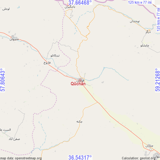
Qūchān GPS coordinates[2]
37° 6' 21.6" North, 58° 30' 34.38" East
| Map corner | latitude | longitude |
|---|---|---|
| Upper-left | 37.66468°, | 57.80643° |
| Center: | 37.106°, | 58.50955° |
| Lower-right: | 36.54317°, | 59.21268° |
| Map W x H: | 124.7×124.7 km | = 77.5×77.5mi |
| max Lat: | 39.6482° ⇑15% North |
| Qūchān: | 37.106° |
| min Lat: | ⇓85% South 25.2919° |
| min Long | Qūchān | max Long |
| 44.38416° | 58.50955° | 61.9965° |
| W 90%⇐ | ⇒10% E |
Elevation
Elevation of Qūchān is 1313 m = 4308 ft, and this is 264 m = 866 ft above average elevation for this country.
| Max E: |
2564 m = 8412 ft | 41.5% |
| Qūchān | 1313 m 4308 ft | |
| Avg. | 1049 m = 3442 ft | |
Min E: |
-24 m = -79 ft | 58.5% |
See also: Qūchān elevation on elevation.city.
Geographical zone
Qūchān is located in North temperate zone (between Tropic of Cancer and the Arctic Circle). Distance of this Northern Tropic circle is 1519.9 km =944.4 mi to South.| Distance of | km | miles | from Qūchān |
|---|---|---|---|
| North Pole | 5881.3 | 3654.5 | to North |
| Arctic Circle | 3275.4 | 2035.2 | to North |
| Tropic Cancer | 1519.9 | 944.4 | to South |
| Equator | 4125.8 | 2563.7 | to South |


Nearby cities:
15 places around Qūchān: (largest is in red/bold)
• Bojnūrd
112.2 km =69.7 mi,  291°
291°
• Bozghān
91.4 km =56.8 mi,  175°
175°
• Chenārān
74.7 km =46.4 mi,  133°
133°
• Dargaz
65 km =40.4 mi,  54°
54°
• Esfarāyen
88.7 km =55.1 mi,  267°
267°
• Fārūj
29.3 km =18.2 mi,  298°
298°
• Joghtāy
138.1 km =85.8 mi,  247°
247°
• Kalāt-e Nāderī
112.1 km =69.7 mi,  96°
96°
• Mashhad
128.9 km =80.1 mi, 132°
• Neqāb
106.4 km =66.1 mi, 245°
• Neyshābūr
102.5 km =63.7 mi,  165°
165°
• Sabzevar
123.8 km =76.9 mi,  216°
216°
• Shīrvān
60.7 km =37.7 mi, 302°
• Solţānābād
88.6 km =55.1 mi,  208°
208°
• Ţorqabeh
117.3 km =72.9 mi,  138°
138°
Sources, notices
• [Note1] Compared only with cities in Iran existing in our database
• [Src1] Map data: © OpenStreetMap contributors (CC-BY-SA)
• [Src2] Other city data from geonames.org with taken over terms of usage.
• [Src3] Geographical zone / Annual Mean Temperature by Robert A. Rohde @ Wikipedia
