Āstārā geodata
Āstārā (Gīlān) is a seat of a second-order administrative division; located in Iran in Asia/Tehran (GMT+3.5) time zone. With population of 39,065 people, there are 154 cities with bigger population in this country. Compared to other cities in Iran, 96.6% of cities are located further ↓South; 73% of cities are located further →East and 100% of cities have higher elevation than Āstārā. Note1


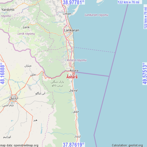
Āstārā GPS coordinates[2]
38° 25' 44.76" North, 48° 52' 19.2" East
| Map corner | latitude | longitude |
|---|---|---|
| Upper-left | 38.97781°, | 48.16888° |
| Center: | 38.4291°, | 48.872° |
| Lower-right: | 37.87619°, | 49.57513° |
| Map W x H: | 122.5×122.5 km | = 76.1×76.1mi |
| max Lat: | 39.6482° ⇑3.4% North |
| Āstārā: | 38.4291° |
| min Lat: | ⇓96.6% South 25.2919° |
| min Long | Āstārā | max Long |
| 44.38416° | 48.872° | 61.9965° |
| W 27%⇐ | ⇒73% E |
Elevation
Elevation of Āstārā is -24 m = -79 ft, and this is 1073 m = 3520 ft below average elevation for this country.
| Max E: |
2564 m = 8412 ft | 100% |
| Avg. | 1049 m = 3442 ft | |
| Āstārā | -24 m = -79 ft | |
Min E: |
-24 m = -79 ft | 0% |
See also: Iran elevation on elevation.city.
Geographical zone
Āstārā is located in North temperate zone (between Tropic of Cancer and the Arctic Circle). Distance of this Northern Tropic circle is 1667 km =1035.8 mi to South.| Distance of | km | miles | from Āstārā |
|---|---|---|---|
| North Pole | 5734.1 | 3563 | to North |
| Arctic Circle | 3128.3 | 1943.8 | to North |
| Tropic Cancer | 1667 | 1035.8 | to South |
| Equator | 4272.9 | 2655.1 | to South |


Nearby cities:
15 places around Āstārā: (largest is in red/bold)
• Ardabīl
54.3 km =33.7 mi,  248°
248°
• Bandar-e Anzalī
118 km =73.3 mi,  154°
154°
• Bīleh Savār
114.8 km =71.3 mi,  337°
337°
• Germī
95.2 km =59.2 mi,  313°
313°
• Gīvī
94.8 km =58.9 mi,  209°
209°
• Hashtpar
70.4 km =43.7 mi,  177°
177°
• Khalkhāl
95 km =59 mi,  198°
198°
• Meshgīn Shahr
103.7 km =64.4 mi,  268°
268°
• Māsāl
120.7 km =75 mi,  169°
169°
• Namīn
33.8 km =21 mi, 269°
• Nīr
88 km =54.7 mi,  240°
240°
• Omīdcheh
65.6 km =40.8 mi,  256°
256°
• Reẕvānshahr
100.5 km =62.4 mi, 166°
• Sarāb
128.7 km =80 mi, 245°
• Ziabar (Gaskar)
116.2 km =72.2 mi,  163°
163°
Sources, notices
• [Note1] Compared only with cities in Iran existing in our database
• [Src1] Map data: © OpenStreetMap contributors (CC-BY-SA)
• [Src2] Other city data from geonames.org with taken over terms of usage.
• [Src3] Geographical zone / Annual Mean Temperature by Robert A. Rohde @ Wikipedia
