Nīr geodata
Nīr (Ardabīl) is a seat of a second-order administrative division; located in Iran in Asia/Tehran (GMT+3.5) time zone. In our database, there are 232 cities with bigger population. Compared to other cities in Iran, 94.6% of cities are located further ↓South; 82.3% of cities are located further →East and 78.9% of cities have lower elevation than Nīr. Note1


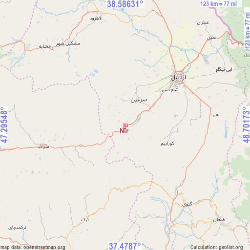
Nīr GPS coordinates[2]
38° 2' 4.56" North, 47° 59' 54.96" East
| Map corner | latitude | longitude |
|---|---|---|
| Upper-left | 38.58631°, | 47.29548° |
| Center: | 38.0346°, | 47.9986° |
| Lower-right: | 37.4787°, | 48.70173° |
| Map W x H: | 123.2×123.2 km | = 76.6×76.6mi |
| max Lat: | 39.6482° ⇑5.4% North |
| Nīr: | 38.0346° |
| min Lat: | ⇓94.6% South 25.2919° |
| min Long | Nīr | max Long |
| 44.38416° | 47.9986° | 61.9965° |
| W 17.7%⇐ | ⇒82.3% E |
Elevation
Elevation of Nīr is 1623 m = 5325 ft, and this is 574 m = 1883 ft above average elevation for this country.
| Max E: |
2564 m = 8412 ft | 21.1% |
| Nīr | 1623 m 5325 ft | |
| Avg. | 1049 m = 3442 ft | |
Min E: |
-24 m = -79 ft | 78.9% |
See also: Iran elevation on elevation.city.
Geographical zone
Nīr is located in North temperate zone (between Tropic of Cancer and the Arctic Circle). Distance of this Northern Tropic circle is 1623.1 km =1008.5 mi to South.| Distance of | km | miles | from Nīr |
|---|---|---|---|
| North Pole | 5778 | 3590.3 | to North |
| Arctic Circle | 3172.1 | 1971.1 | to North |
| Tropic Cancer | 1623.1 | 1008.5 | to South |
| Equator | 4229.1 | 2627.8 | to South |


Nearby cities:
15 places around Nīr: (largest is in red/bold)
• Ahar
94.9 km =59 mi,  301°
301°
• Ardabīl
35.2 km =21.9 mi,  47°
47°
• Bostānābād
104.1 km =64.7 mi,  258°
258°
• Germī
110 km =68.4 mi,  3°
3°
• Gīvī
49.1 km =30.5 mi,  142°
142°
• Hashtpar
83.8 km =52.1 mi,  108°
108°
• Hashtrūd
103.8 km =64.5 mi,  233°
233°
• Herīs
80.7 km =50.1 mi,  287°
287°
• Khalkhāl
65.7 km =40.8 mi,  134°
134°
• Meshgīn Shahr
49.1 km =30.5 mi,  325°
325°
• Mīāneh
72.6 km =45.1 mi,  200°
200°
• Namīn
60.8 km =37.8 mi,  44°
44°
• Omīdcheh
30.7 km =19.1 mi,  24°
24°
• Sarāb
41.8 km =26 mi, 255°
• Āstārā
88 km =54.7 mi,  60°
60°
Sources, notices
• [Note1] Compared only with cities in Iran existing in our database
• [Src1] Map data: © OpenStreetMap contributors (CC-BY-SA)
• [Src2] Other city data from geonames.org with taken over terms of usage.
• [Src3] Geographical zone / Annual Mean Temperature by Robert A. Rohde @ Wikipedia
