Bīleh Savār geodata
Bīleh Savār (Ardabīl) is a seat of a second-order administrative division; located in Iran in Asia/Tehran (GMT+3.5) time zone. With population of 14,000 people, there are 203 cities with bigger population in this country. Compared to other cities in Iran, 99.8% of cities are located further ↓South; 78.5% of cities are located further →East and 82.3% of cities have higher elevation than Bīleh Savār. Note1


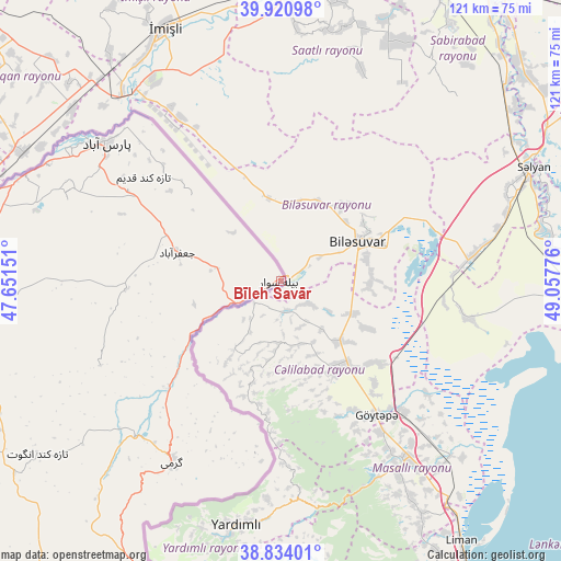
Bīleh Savār GPS coordinates[2]
39° 22' 46.596" North, 48° 21' 16.668" East
| Map corner | latitude | longitude |
|---|---|---|
| Upper-left | 39.92098°, | 47.65151° |
| Center: | 39.37961°, | 48.35463° |
| Lower-right: | 38.83401°, | 49.05776° |
| Map W x H: | 120.9×120.9 km | = 75.1×75.1mi |
| max Lat: | 39.6482° ⇑0.2% North |
| Bīleh Savār: | 39.37961° |
| min Lat: | ⇓99.8% South 25.2919° |
| min Long | Bīleh Savār | max Long |
| 44.38416° | 48.35463° | 61.9965° |
| W 21.5%⇐ | ⇒78.5% E |
Elevation
Elevation of Bīleh Savār is 83 m = 272 ft, and this is 966 m = 3169 ft below average elevation for this country.
| Max E: |
2564 m = 8412 ft | 82.3% |
| Avg. | 1049 m = 3442 ft | |
| Bīleh Savār | 83 m = 272 ft | |
Min E: |
-24 m = -79 ft | 17.7% |
See also: Iran elevation on elevation.city.
Geographical zone
Bīleh Savār is located in North temperate zone (between Tropic of Cancer and the Arctic Circle). Distance of this Northern Tropic circle is 1772.7 km =1101.5 mi to South.| Distance of | km | miles | from Bīleh Savār |
|---|---|---|---|
| North Pole | 5628.5 | 3497.4 | to North |
| Arctic Circle | 3022.6 | 1878.2 | to North |
| Tropic Cancer | 1772.7 | 1101.5 | to South |
| Equator | 4378.6 | 2720.7 | to South |


Nearby cities:
15 places around Bīleh Savār: (largest is in red/bold)
• Ahar
149.7 km =93 mi,  227°
227°
• Ardabīl
125.7 km =78.1 mi,  182°
182°
• Germī
46.3 km =28.8 mi,  210°
210°
• Gīvī
188.3 km =117 mi, 180°
• Hashtpar
182.4 km =113.3 mi,  164°
164°
• Herīs
165.3 km =102.7 mi,  220°
220°
• Kaleybar
127.1 km =79 mi,  243°
243°
• Khomārlū
116.5 km =72.4 mi,  257°
257°
• Meshgīn Shahr
123.6 km =76.8 mi, 208°
• Namīn
106.5 km =66.2 mi,  173°
173°
• Nīr
152.7 km =94.9 mi,  191°
191°
• Omīdcheh
122.9 km =76.4 mi, 188°
• Pārsābād
47.9 km =29.8 mi,  308°
308°
• Sarāb
175 km =108.7 mi,  203°
203°
• Āstārā
114.8 km =71.3 mi, 157°
Sources, notices
• [Note1] Compared only with cities in Iran existing in our database
• [Src1] Map data: © OpenStreetMap contributors (CC-BY-SA)
• [Src2] Other city data from geonames.org with taken over terms of usage.
• [Src3] Geographical zone / Annual Mean Temperature by Robert A. Rohde @ Wikipedia
