Ardabīl geodata
Ardabīl is a seat of a first-order administrative division; located in Iran in Asia/Tehran (GMT+3.5) time zone. With population of 410,753 people, there are 19 cities with bigger population in this country. Compared to other cities in Iran, 95.7% of cities are located further ↓South; 79.4% of cities are located further →East and 62.1% of cities have lower elevation than Ardabīl. Note1


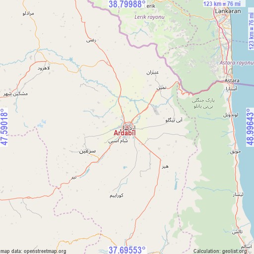
Ardabīl GPS coordinates[2]
38° 14' 59.28" North, 48° 17' 35.88" East
| Map corner | latitude | longitude |
|---|---|---|
| Upper-left | 38.79988°, | 47.59018° |
| Center: | 38.2498°, | 48.2933° |
| Lower-right: | 37.69553°, | 48.99643° |
| Map W x H: | 122.8×122.8 km | = 76.3×76.3mi |
| max Lat: | 39.6482° ⇑4.3% North |
| Ardabīl: | 38.2498° |
| min Lat: | ⇓95.7% South 25.2919° |
| min Long | Ardabīl | max Long |
| 44.38416° | 48.2933° | 61.9965° |
| W 20.6%⇐ | ⇒79.4% E |
Elevation
Elevation of Ardabīl is 1353 m = 4439 ft, and this is 304 m = 997 ft above average elevation for this country.
| Max E: |
2564 m = 8412 ft | 37.9% |
| Ardabīl | 1353 m 4439 ft | |
| Avg. | 1049 m = 3442 ft | |
Min E: |
-24 m = -79 ft | 62.1% |
See also: Ardabīl elevation on elevation.city.
Geographical zone
Ardabīl is located in North temperate zone (between Tropic of Cancer and the Arctic Circle). Distance of this Northern Tropic circle is 1647.1 km =1023.5 mi to South.| Distance of | km | miles | from Ardabīl |
|---|---|---|---|
| North Pole | 5754.1 | 3575.4 | to North |
| Arctic Circle | 3148.2 | 1956.2 | to North |
| Tropic Cancer | 1647.1 | 1023.5 | to South |
| Equator | 4253 | 2642.7 | to South |


Nearby cities:
15 places around Ardabīl: (largest is in red/bold)
• Ahar
109.6 km =68.1 mi,  283°
283°
• Germī
87.8 km =54.6 mi,  347°
347°
• Gīvī
62.9 km =39.1 mi,  176°
176°
• Hashtpar
73.6 km =45.7 mi,  133°
133°
• Herīs
102.7 km =63.8 mi,  269°
269°
• Khalkhāl
73.2 km =45.5 mi,  163°
163°
• Meshgīn Shahr
55.8 km =34.7 mi,  287°
287°
• Māsāl
123.1 km =76.5 mi,  143°
143°
• Mīāneh
105.2 km =65.4 mi,  208°
208°
• Namīn
25.8 km =16 mi,  40°
40°
• Nīr
35.2 km =21.9 mi,  227°
227°
• Omīdcheh
13.9 km =8.6 mi, 287°
• Reẕvānshahr
107.4 km =66.7 mi, 136°
• Sarāb
74.6 km =46.4 mi,  242°
242°
• Āstārā
54.3 km =33.7 mi,  68°
68°
Sources, notices
• [Note1] Compared only with cities in Iran existing in our database
• [Src1] Map data: © OpenStreetMap contributors (CC-BY-SA)
• [Src2] Other city data from geonames.org with taken over terms of usage.
• [Src3] Geographical zone / Annual Mean Temperature by Robert A. Rohde @ Wikipedia
