Langarūd geodata
Langarūd (Gīlān) is a seat of a second-order administrative division; located in Iran in Asia/Tehran (GMT+3.5) time zone. With population of 68,148 people, there are 98 cities with bigger population in this country. Compared to other cities in Iran, 86.4% of cities are located further ↓South; 60.8% of cities are located further →East and 95.9% of cities have higher elevation than Langarūd. Note1


Langarūd GPS coordinates[2]
37° 11' 43.728" North, 50° 9' 9.468" East
| Map corner | latitude | longitude |
|---|---|---|
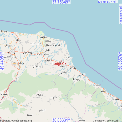
| Upper-left | 37.75349°, | 49.44951° |
| Center: | 37.19548°, | 50.15263° |
| Lower-right: | 36.63331°, | 50.85576° |
| Map W x H: | 124.6×124.6 km | = 77.4×77.4mi |
| max Lat: | 39.6482° ⇑13.6% North |
| Langarūd: | 37.19548° |
| min Lat: | ⇓86.4% South 25.2919° |
| min Long | Langarūd | max Long |
| 44.38416° | 50.15263° | 61.9965° |
| W 39.2%⇐ | ⇒60.8% E |
Elevation
Elevation of Langarūd is -1 m = -3 ft, and this is 1050 m = 3445 ft below average elevation for this country.
| Max E: |
2564 m = 8412 ft | 95.9% |
| Avg. | 1049 m = 3442 ft | |
| Langarūd | -1 m = -3 ft | |
Min E: |
-24 m = -79 ft | 4.1% |
See also: Langarūd elevation on elevation.city.
Geographical zone
Langarūd is located in North temperate zone (between Tropic of Cancer and the Arctic Circle). Distance of this Northern Tropic circle is 1529.8 km =950.6 mi to South.| Distance of | km | miles | from Langarūd |
|---|---|---|---|
| North Pole | 5871.3 | 3648.3 | to North |
| Arctic Circle | 3265.4 | 2029 | to North |
| Tropic Cancer | 1529.8 | 950.6 | to South |
| Equator | 4135.7 | 2569.8 | to South |


Nearby cities:
15 places around Langarūd: (largest is in red/bold)
• Amlash
11.4 km =7.1 mi,  164°
164°
• Bandar-e Anzalī
68.7 km =42.7 mi,  296°
296°
• Fūman
74.5 km =46.3 mi,  272°
272°
• Lāhījān
12.7 km =7.9 mi, 274°
• Pādegān-e Manjīl
82.6 km =51.3 mi,  232°
232°
• Pā’īn-e Bāzār-e Rūdbār
76.8 km =47.7 mi,  237°
237°
• Rasht
50.7 km =31.5 mi,  280°
280°
• Rāmsar
53.7 km =33.4 mi,  125°
125°
• Rūdsar
13.9 km =8.6 mi,  117°
117°
• Shaft
66.7 km =41.4 mi, 267°
• Sīāhkal
25.4 km =15.8 mi,  259°
259°
• Tonekābon
76.7 km =47.7 mi, 123°
• Ziabar (Gaskar)
84.2 km =52.3 mi,  287°
287°
• Āstāneh-ye Ashrafīyeh
20 km =12.4 mi, 292°
• Şowme‘eh Sarā
75.1 km =46.7 mi, 279°
Sources, notices
• [Note1] Compared only with cities in Iran existing in our database
• [Src1] Map data: © OpenStreetMap contributors (CC-BY-SA)
• [Src2] Other city data from geonames.org with taken over terms of usage.
• [Src3] Geographical zone / Annual Mean Temperature by Robert A. Rohde @ Wikipedia
