Zanjān geodata
Zanjān (Zanjan) is a seat of a first-order administrative division; located in Iran in Asia/Tehran (GMT+3.5) time zone. With population of 357,471 people, there are 21 cities with bigger population in this country. Compared to other cities in Iran, 77.1% of cities are located further ↓South; 76% of cities are located further →East and 80.7% of cities have lower elevation than Zanjān. Note1


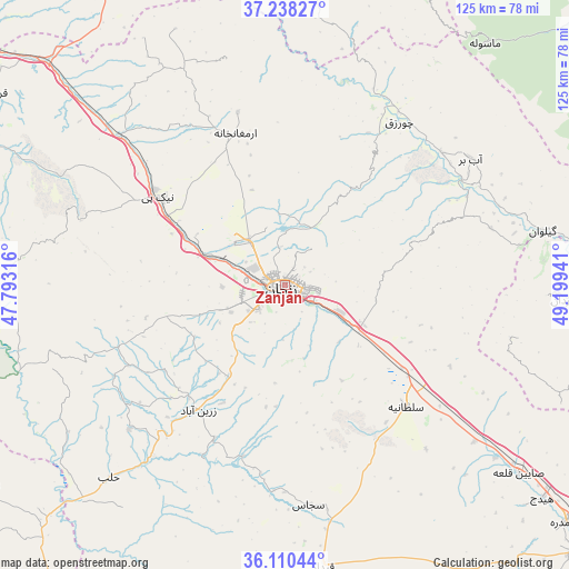
Zanjān GPS coordinates[2]
36° 40' 35.112" North, 48° 29' 46.608" East
| Map corner | latitude | longitude |
|---|---|---|
| Upper-left | 37.23827°, | 47.79316° |
| Center: | 36.67642°, | 48.49628° |
| Lower-right: | 36.11044°, | 49.19941° |
| Map W x H: | 125.4×125.4 km | = 77.9×77.9mi |
| max Lat: | 39.6482° ⇑22.9% North |
| Zanjān: | 36.67642° |
| min Lat: | ⇓77.1% South 25.2919° |
| min Long | Zanjān | max Long |
| 44.38416° | 48.49628° | 61.9965° |
| W 24%⇐ | ⇒76% E |
Elevation
Elevation of Zanjān is 1666 m = 5466 ft, and this is 617 m = 2024 ft above average elevation for this country.
| Max E: |
2564 m = 8412 ft | 19.3% |
| Zanjān | 1666 m 5466 ft | |
| Avg. | 1049 m = 3442 ft | |
Min E: |
-24 m = -79 ft | 80.7% |
See also: Zanjān elevation on elevation.city.
Geographical zone
Zanjān is located in North temperate zone (between Tropic of Cancer and the Arctic Circle). Distance of this Northern Tropic circle is 1472.1 km =914.7 mi to South.| Distance of | km | miles | from Zanjān |
|---|---|---|---|
| North Pole | 5929 | 3684.1 | to North |
| Arctic Circle | 3323.1 | 2064.9 | to North |
| Tropic Cancer | 1472.1 | 914.7 | to South |
| Equator | 4078 | 2534 | to South |


Nearby cities:
15 places around Zanjān: (largest is in red/bold)
• Abhar
87.4 km =54.3 mi,  132°
132°
• Alvand
72 km =44.7 mi,  123°
123°
• Fūman
94.7 km =58.8 mi,  49°
49°
• Khalkhāl
104.8 km =65.1 mi,  1°
1°
• Khorramdarreh
81.4 km =50.6 mi, 129°
• Māhneshān
73.8 km =45.9 mi,  275°
275°
• Māsāl
95 km =59 mi,  36°
36°
• Māsūleh
69 km =42.9 mi, 39°
• Pādegān-e Manjīl
82.3 km =51.1 mi,  84°
84°
• Pā’īn-e Bāzār-e Rūdbār
84.4 km =52.4 mi, 79°
• Shaft
97.3 km =60.5 mi,  55°
55°
• Zarrīnābād
33.8 km =21 mi,  214°
214°
• Ziabar (Gaskar)
106.6 km =66.2 mi, 38°
• Ābbar
49.6 km =30.8 mi, 55°
• Şowme‘eh Sarā
100.6 km =62.5 mi, 46°
Sources, notices
• [Note1] Compared only with cities in Iran existing in our database
• [Src1] Map data: © OpenStreetMap contributors (CC-BY-SA)
• [Src2] Other city data from geonames.org with taken over terms of usage.
• [Src3] Geographical zone / Annual Mean Temperature by Robert A. Rohde @ Wikipedia
