Kahrīz geodata
Kahrīz (Kermānshāh) is a populated place; located in Iran in Asia/Tehran (GMT+3.5) time zone. With population of 766,706 people, there are 9 cities with bigger population in this country. Compared to other cities in Iran, 50.1% of cities are located further ↓South; 87.8% of cities are located further →East and 58% of cities have lower elevation than Kahrīz. Note1


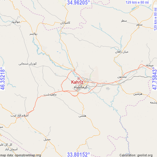
Kahrīz GPS coordinates[2]
34° 23' 1.68" North, 47° 3' 19.08" East
| Map corner | latitude | longitude |
|---|---|---|
| Upper-left | 34.96205°, | 46.35218° |
| Center: | 34.3838°, | 47.0553° |
| Lower-right: | 33.80152°, | 47.75843° |
| Map W x H: | 129×129 km | = 80.2×80.2mi |
| max Lat: | 39.6482° ⇑49.9% North |
| Kahrīz: | 34.3838° |
| min Lat: | ⇓50.1% South 25.2919° |
| min Long | Kahrīz | max Long |
| 44.38416° | 47.0553° | 61.9965° |
| W 12.2%⇐ | ⇒87.8% E |
Elevation
Elevation of Kahrīz is 1302 m = 4272 ft, and this is 253 m = 830 ft above average elevation for this country.
| Max E: |
2564 m = 8412 ft | 42% |
| Kahrīz | 1302 m 4272 ft | |
| Avg. | 1049 m = 3442 ft | |
Min E: |
-24 m = -79 ft | 58% |
See also: Kahrīz elevation on elevation.city.
Geographical zone
Kahrīz is located in North temperate zone (between Tropic of Cancer and the Arctic Circle). Distance of this Northern Tropic circle is 1217.2 km =756.3 mi to South.| Distance of | km | miles | from Kahrīz |
|---|---|---|---|
| North Pole | 6183.9 | 3842.5 | to North |
| Arctic Circle | 3578.1 | 2223.3 | to North |
| Tropic Cancer | 1217.2 | 756.3 | to South |
| Equator | 3823.1 | 2375.6 | to South |


Nearby cities:
15 places around Kahrīz: (largest is in red/bold)
• Eslāmābād-e Gharb
57.3 km =35.6 mi,  237°
237°
• Eyvān
92.4 km =57.4 mi,  227°
227°
• Harsīn
50.3 km =31.3 mi,  104°
104°
• Javānrūd
67.3 km =41.8 mi,  312°
312°
• Javānrūd
69.8 km =43.4 mi, 312°
• Kangāvar
84.5 km =52.5 mi,  80°
80°
• Kerend-e Gharb
75.5 km =46.9 mi,  261°
261°
• Kermanshah
7.8 km =4.8 mi,  173°
173°
• Kāmyārān
47.1 km =29.3 mi,  346°
346°
• Nūrābād
91.1 km =56.6 mi,  112°
112°
• Ravānsar
52.1 km =32.4 mi,  315°
315°
• Sarābleh
82 km =51 mi,  213°
213°
• Sonqor
66.6 km =41.4 mi,  48°
48°
• Tāzehābād
91.8 km =57 mi,  295°
295°
• Şaḩneh
59.3 km =36.8 mi, 79°
Sources, notices
• [Note1] Compared only with cities in Iran existing in our database
• [Src1] Map data: © OpenStreetMap contributors (CC-BY-SA)
• [Src2] Other city data from geonames.org with taken over terms of usage.
• [Src3] Geographical zone / Annual Mean Temperature by Robert A. Rohde @ Wikipedia
