Şaḩneh geodata
Şaḩneh (Kermānshāh) is a seat of a second-order administrative division; located in Iran in Asia/Tehran (GMT+3.5) time zone. In our database, there are 232 cities with bigger population. Compared to other cities in Iran, 50.8% of cities are located further ↓South; 83.9% of cities are located further →East and 62.8% of cities have lower elevation than Şaḩneh. Note1


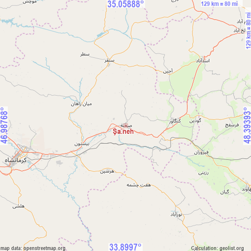
Şaḩneh GPS coordinates[2]
34° 28' 52.68" North, 47° 41' 26.88" East
| Map corner | latitude | longitude |
|---|---|---|
| Upper-left | 35.05888°, | 46.98768° |
| Center: | 34.4813°, | 47.6908° |
| Lower-right: | 33.8997°, | 48.39393° |
| Map W x H: | 128.9×128.9 km | = 80.1×80.1mi |
| max Lat: | 39.6482° ⇑49.2% North |
| Şaḩneh: | 34.4813° |
| min Lat: | ⇓50.8% South 25.2919° |
| min Long | Şaḩneh | max Long |
| 44.38416° | 47.6908° | 61.9965° |
| W 16.1%⇐ | ⇒83.9% E |
Elevation
Elevation of Şaḩneh is 1364 m = 4475 ft, and this is 315 m = 1033 ft above average elevation for this country.
| Max E: |
2564 m = 8412 ft | 37.2% |
| Şaḩneh | 1364 m 4475 ft | |
| Avg. | 1049 m = 3442 ft | |
Min E: |
-24 m = -79 ft | 62.8% |
See also: Iran elevation on elevation.city.
Geographical zone
Şaḩneh is located in North temperate zone (between Tropic of Cancer and the Arctic Circle). Distance of this Northern Tropic circle is 1228 km =763 mi to South.| Distance of | km | miles | from Şaḩneh |
|---|---|---|---|
| North Pole | 6173.1 | 3835.8 | to North |
| Arctic Circle | 3567.2 | 2216.6 | to North |
| Tropic Cancer | 1228 | 763 | to South |
| Equator | 3834 | 2382.3 | to South |


Nearby cities:
15 places around Şaḩneh: (largest is in red/bold)
• Asadābād
51.6 km =32.1 mi,  49°
49°
• Bahār
83.4 km =51.8 mi,  55°
55°
• Hamadān
83.2 km =51.7 mi, 64°
• Harsīn
25.2 km =15.7 mi,  202°
202°
• Kahrīz
59.3 km =36.8 mi,  259°
259°
• Kangāvar
25.3 km =15.7 mi,  84°
84°
• Kermanshah
60.3 km =37.5 mi,  252°
252°
• Kāmyārān
77.4 km =48.1 mi,  296°
296°
• Nahāvand
70.6 km =43.9 mi,  117°
117°
• Nūrābād
52.2 km =32.4 mi,  150°
150°
• Pasragad Branch
78.7 km =48.9 mi,  65°
65°
• Qorveh
76.9 km =47.8 mi,  7°
7°
• Sonqor
34.4 km =21.4 mi,  345°
345°
• Tūyserkān
69.4 km =43.1 mi, 83°
• pamas
86.3 km =53.6 mi, 124°
Sources, notices
• [Note1] Compared only with cities in Iran existing in our database
• [Src1] Map data: © OpenStreetMap contributors (CC-BY-SA)
• [Src2] Other city data from geonames.org with taken over terms of usage.
• [Src3] Geographical zone / Annual Mean Temperature by Robert A. Rohde @ Wikipedia
