Kāmyārān geodata
Kāmyārān (Kordestān) is a seat of a second-order administrative division; located in Iran in Asia/Tehran (GMT+3.5) time zone. With population of 61,642 people, there are 105 cities with bigger population in this country. Compared to other cities in Iran, 54.9% of cities are located further ↓South; 89.1% of cities are located further →East and 68.7% of cities have lower elevation than Kāmyārān. Note1


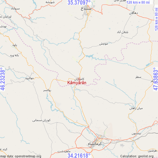
Kāmyārān GPS coordinates[2]
34° 47' 44.16" North, 46° 56' 7.8" East
| Map corner | latitude | longitude |
|---|---|---|
| Upper-left | 35.37097°, | 46.23238° |
| Center: | 34.7956°, | 46.9355° |
| Lower-right: | 34.21618°, | 47.63863° |
| Map W x H: | 128.4×128.4 km | = 79.8×79.8mi |
| max Lat: | 39.6482° ⇑45.1% North |
| Kāmyārān: | 34.7956° |
| min Lat: | ⇓54.9% South 25.2919° |
| min Long | Kāmyārān | max Long |
| 44.38416° | 46.9355° | 61.9965° |
| W 10.9%⇐ | ⇒89.1% E |
Elevation
Elevation of Kāmyārān is 1470 m = 4823 ft, and this is 421 m = 1381 ft above average elevation for this country.
| Max E: |
2564 m = 8412 ft | 31.3% |
| Kāmyārān | 1470 m 4823 ft | |
| Avg. | 1049 m = 3442 ft | |
Min E: |
-24 m = -79 ft | 68.7% |
See also: Kāmyārān elevation on elevation.city.
Geographical zone
Kāmyārān is located in North temperate zone (between Tropic of Cancer and the Arctic Circle). Distance of this Northern Tropic circle is 1263 km =784.8 mi to South.| Distance of | km | miles | from Kāmyārān |
|---|---|---|---|
| North Pole | 6138.2 | 3814.1 | to North |
| Arctic Circle | 3532.3 | 2194.9 | to North |
| Tropic Cancer | 1263 | 784.8 | to South |
| Equator | 3868.9 | 2404 | to South |


Nearby cities:
15 places around Kāmyārān: (largest is in red/bold)
• Dehgolān
69.4 km =43.1 mi,  39°
39°
• Eslāmābād-e Gharb
85 km =52.8 mi,  206°
206°
• Harsīn
83.3 km =51.8 mi,  134°
134°
• Javānrūd
38.2 km =23.7 mi,  270°
270°
• Javānrūd
40.6 km =25.2 mi, 271°
• Kahrīz
47.1 km =29.3 mi,  166°
166°
• Kerend-e Gharb
85.2 km =52.9 mi,  228°
228°
• Kermanshah
54.8 km =34.1 mi, 167°
• Pāveh
59.5 km =37 mi,  297°
297°
• Ravānsar
27.3 km =17 mi,  250°
250°
• Sanandaj
58 km =36 mi,  5°
5°
• Sarvābād
77.3 km =48 mi,  318°
318°
• Sonqor
60.6 km =37.7 mi,  91°
91°
• Tāzehābād
72.1 km =44.8 mi,  264°
264°
• Şaḩneh
77.4 km =48.1 mi,  116°
116°
Sources, notices
• [Note1] Compared only with cities in Iran existing in our database
• [Src1] Map data: © OpenStreetMap contributors (CC-BY-SA)
• [Src2] Other city data from geonames.org with taken over terms of usage.
• [Src3] Geographical zone / Annual Mean Temperature by Robert A. Rohde @ Wikipedia
