Tāzehābād geodata
Tāzehābād (Kermānshāh) is a seat of a second-order administrative division; located in Iran in Asia/Tehran (GMT+3.5) time zone. In our database, there are 232 cities with bigger population. Compared to other cities in Iran, 53.5% of cities are located further ↓South; 93.9% of cities are located further →East and 54.2% of cities have lower elevation than Tāzehābād. Note1


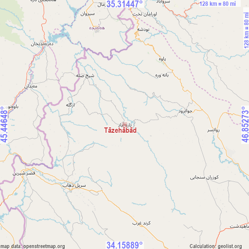
Tāzehābād GPS coordinates[2]
34° 44' 19.32" North, 46° 8' 58.56" East
| Map corner | latitude | longitude |
|---|---|---|
| Upper-left | 35.31447°, | 45.44648° |
| Center: | 34.7387°, | 46.1496° |
| Lower-right: | 34.15889°, | 46.85273° |
| Map W x H: | 128.5×128.5 km | = 79.8×79.8mi |
| max Lat: | 39.6482° ⇑46.5% North |
| Tāzehābād: | 34.7387° |
| min Lat: | ⇓53.5% South 25.2919° |
| min Long | Tāzehābād | max Long |
| 44.38416° | 46.1496° | 61.9965° |
| W 6.1%⇐ | ⇒93.9% E |
Elevation
Elevation of Tāzehābād is 1231 m = 4039 ft, and this is 182 m = 597 ft above average elevation for this country.
| Max E: |
2564 m = 8412 ft | 45.8% |
| Tāzehābād | 1231 m 4039 ft | |
| Avg. | 1049 m = 3442 ft | |
Min E: |
-24 m = -79 ft | 54.2% |
See also: Iran elevation on elevation.city.
Geographical zone
Tāzehābād is located in North temperate zone (between Tropic of Cancer and the Arctic Circle). Distance of this Northern Tropic circle is 1256.7 km =780.9 mi to South.| Distance of | km | miles | from Tāzehābād |
|---|---|---|---|
| North Pole | 6144.5 | 3818 | to North |
| Arctic Circle | 3538.6 | 2198.8 | to North |
| Tropic Cancer | 1256.7 | 780.9 | to South |
| Equator | 3862.6 | 2400.1 | to South |


Nearby cities:
15 places around Tāzehābād: (largest is in red/bold)
• Eslāmābād-e Gharb
78.1 km =48.5 mi,  153°
153°
• Gīlān-e Gharb
69.6 km =43.2 mi,  197°
197°
• Javānrūd
32.1 km =19.9 mi,  76°
76°
• Javānrūd
34.2 km =21.3 mi, 79°
• Kahrīz
91.8 km =57 mi,  115°
115°
• Kerend-e Gharb
51.2 km =31.8 mi,  170°
170°
• Kermanshah
96.2 km =59.8 mi, 119°
• Kāmyārān
72.1 km =44.8 mi, 84°
• Marīvān
86.7 km =53.9 mi,  2°
2°
• Pāveh
38.8 km =24.1 mi,  29°
29°
• Qaşr-e Shīrīn
57.8 km =35.9 mi,  244°
244°
• Ravānsar
46.1 km =28.6 mi,  93°
93°
• Sanandaj
100.4 km =62.4 mi,  50°
50°
• Sarpol-e Z̄ahāb
40.5 km =25.2 mi,  220°
220°
• Sarvābād
66.8 km =41.5 mi,  17°
17°
Sources, notices
• [Note1] Compared only with cities in Iran existing in our database
• [Src1] Map data: © OpenStreetMap contributors (CC-BY-SA)
• [Src2] Other city data from geonames.org with taken over terms of usage.
• [Src3] Geographical zone / Annual Mean Temperature by Robert A. Rohde @ Wikipedia
