Sonqor geodata
Sonqor (Kermānshāh) is a seat of a second-order administrative division; located in Iran in Asia/Tehran (GMT+3.5) time zone. With population of 43,174 people, there are 147 cities with bigger population in this country. Compared to other cities in Iran, 54.2% of cities are located further ↓South; 85% of cities are located further →East and 82.1% of cities have lower elevation than Sonqor. Note1


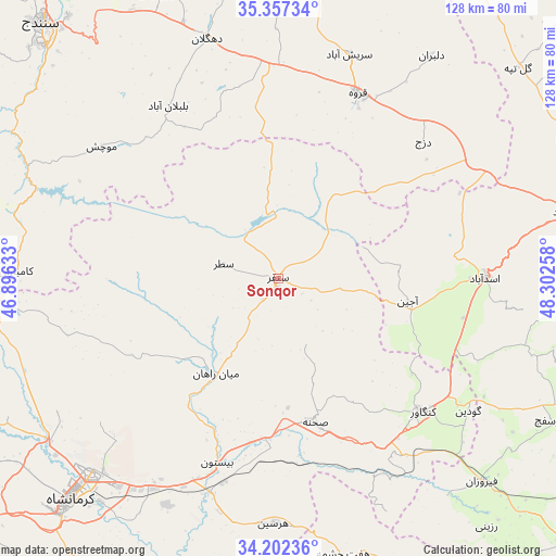
Sonqor GPS coordinates[2]
34° 46' 54.732" North, 47° 35' 58.02" East
| Map corner | latitude | longitude |
|---|---|---|
| Upper-left | 35.35734°, | 46.89633° |
| Center: | 34.78187°, | 47.59945° |
| Lower-right: | 34.20236°, | 48.30258° |
| Map W x H: | 128.4×128.4 km | = 79.8×79.8mi |
| max Lat: | 39.6482° ⇑45.8% North |
| Sonqor: | 34.78187° |
| min Lat: | ⇓54.2% South 25.2919° |
| min Long | Sonqor | max Long |
| 44.38416° | 47.59945° | 61.9965° |
| W 15%⇐ | ⇒85% E |
Elevation
Elevation of Sonqor is 1697 m = 5568 ft, and this is 648 m = 2126 ft above average elevation for this country.
| Max E: |
2564 m = 8412 ft | 17.9% |
| Sonqor | 1697 m 5568 ft | |
| Avg. | 1049 m = 3442 ft | |
Min E: |
-24 m = -79 ft | 82.1% |
See also: Sonqor elevation on elevation.city.
Geographical zone
Sonqor is located in North temperate zone (between Tropic of Cancer and the Arctic Circle). Distance of this Northern Tropic circle is 1261.5 km =783.9 mi to South.| Distance of | km | miles | from Sonqor |
|---|---|---|---|
| North Pole | 6139.7 | 3815 | to North |
| Arctic Circle | 3533.8 | 2195.8 | to North |
| Tropic Cancer | 1261.5 | 783.9 | to South |
| Equator | 3867.4 | 2403.1 | to South |


Nearby cities:
15 places around Sonqor: (largest is in red/bold)
• Asadābād
47.5 km =29.5 mi,  89°
89°
• Bahār
78.1 km =48.5 mi,  79°
79°
• Dehgolān
57.6 km =35.8 mi,  343°
343°
• Hamadān
83.6 km =51.9 mi, 88°
• Harsīn
56.7 km =35.2 mi,  181°
181°
• Kahrīz
66.6 km =41.4 mi,  228°
228°
• Kangāvar
45.5 km =28.3 mi,  132°
132°
• Kermanshah
71.4 km =44.4 mi,  223°
223°
• Kāmyārān
60.6 km =37.7 mi,  271°
271°
• Pasragad Branch
79.7 km =49.5 mi, 90°
• Qohūrd-e ‘Olyā
84.9 km =52.8 mi,  30°
30°
• Qorveh
46.7 km =29 mi,  23°
23°
• Sanandaj
80.6 km =50.1 mi,  317°
317°
• Tūyserkān
81.3 km =50.5 mi,  108°
108°
• Şaḩneh
34.4 km =21.4 mi,  165°
165°
Sources, notices
• [Note1] Compared only with cities in Iran existing in our database
• [Src1] Map data: © OpenStreetMap contributors (CC-BY-SA)
• [Src2] Other city data from geonames.org with taken over terms of usage.
• [Src3] Geographical zone / Annual Mean Temperature by Robert A. Rohde @ Wikipedia
