Midori geodata
Midori (Gunma) is a seat of a second-order administrative division; located in Japan in Asia/Tokyo (GMT+9) time zone. In our database, there are 767 cities with bigger population. Compared to other cities in Japan, 76.7% of cities are located further ↓South; 64.2% of cities are located further ←West and 91.7% of cities have lower elevation than Midori. Note1


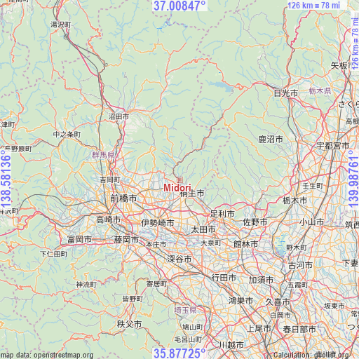
Midori GPS coordinates[2]
36° 26' 41.712" North, 139° 17' 4.128" East
| Map corner | latitude | longitude |
|---|---|---|
| Upper-left | 37.00847°, | 138.58136° |
| Center: | 36.44492°, | 139.28448° |
| Lower-right: | 35.87725°, | 139.98761° |
| Map W x H: | 125.8×125.8 km | = 78.2×78.2mi |
| max Lat: | 45.40944° ⇑23.3% North |
| Midori: | 36.44492° |
| min Lat: | ⇓76.7% South 24.34478° |
| min Long | Midori | max Long |
| 123° | 139.28448° | 145.575° |
| W 64.2%⇐ | ⇒35.8% E |
Elevation
Elevation of Midori is 254 m = 833 ft, and this is 169.4 m = 556 ft above average elevation for this country.
| Max E: |
1086 m = 3563 ft | 8.3% |
| Midori | 254 m 833 ft | |
| Avg. | 84.6 m = 278 ft | |
Min E: |
-2 m = -7 ft | 91.7% |
See also: Japan elevation on elevation.city.
Geographical zone
Midori is located in North temperate zone (between Tropic of Cancer and the Arctic Circle). Distance of this Northern Tropic circle is 1446.4 km =898.8 mi to South.| Distance of | km | miles | from Midori |
|---|---|---|---|
| North Pole | 5954.8 | 3700.1 | to North |
| Arctic Circle | 3348.9 | 2080.9 | to North |
| Tropic Cancer | 1446.4 | 898.8 | to South |
| Equator | 4052.3 | 2518 | to South |


Nearby cities:
15 places around Midori: (largest is in red/bold)
• Ashikaga
19.3 km =12 mi,  129°
129°
• Fukayachō
27.2 km =16.9 mi,  180°
180°
• Honjō
24.5 km =15.2 mi,  200°
200°
• Isesaki
16.1 km =10 mi,  207°
207°
• Kanekomachi
26.1 km =16.2 mi,  261°
261°
• Kiryū
6.6 km =4.1 mi,  138°
138°
• Maebashi
18.7 km =11.6 mi,  254°
254°
• Menuma
26.2 km =16.3 mi,  160°
160°
• Sakai-nakajima
20.1 km =12.5 mi,  188°
188°
• Shibukawa
25.8 km =16 mi,  279°
279°
• Takasaki
27 km =16.8 mi,  242°
242°
• Tamamura
22 km =13.7 mi,  222°
222°
• Tanuma
28.1 km =17.5 mi,  108°
108°
• Ōmamachō-ōmama
1.7 km =1.1 mi, 209°
• Ōta
17.7 km =11 mi, 155°
Sources, notices
• [Note1] Compared only with cities in Japan existing in our database
• [Src1] Map data: © OpenStreetMap contributors (CC-BY-SA)
• [Src2] Other city data from geonames.org with taken over terms of usage.
• [Src3] Geographical zone / Annual Mean Temperature by Robert A. Rohde @ Wikipedia
