Shibukawa geodata
Shibukawa (Gunma) is a seat of a second-order administrative division; located in Japan in Asia/Tokyo (GMT+9) time zone. With population of 48,322 people, there are 387 cities with bigger population in this country. Compared to other cities in Japan, 77.2% of cities are located further ↓South; 60.6% of cities are located further ←West and 88.3% of cities have lower elevation than Shibukawa. Note1


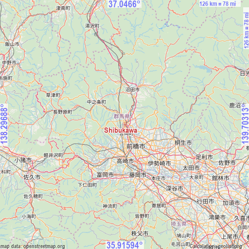
Shibukawa GPS coordinates[2]
36° 28' 59.988" North, 139° 0' 0" East
| Map corner | latitude | longitude |
|---|---|---|
| Upper-left | 37.0466°, | 138.29688° |
| Center: | 36.48333°, | 139° |
| Lower-right: | 35.91594°, | 139.70313° |
| Map W x H: | 125.7×125.7 km | = 78.1×78.1mi |
| max Lat: | 45.40944° ⇑22.8% North |
| Shibukawa: | 36.48333° |
| min Lat: | ⇓77.2% South 24.34478° |
| min Long | Shibukawa | max Long |
| 123° | 139° | 145.575° |
| W 60.6%⇐ | ⇒39.4% E |
Elevation
Elevation of Shibukawa is 202 m = 663 ft, and this is 117.4 m = 385 ft above average elevation for this country.
| Max E: |
1086 m = 3563 ft | 11.7% |
| Shibukawa | 202 m 663 ft | |
| Avg. | 84.6 m = 278 ft | |
Min E: |
-2 m = -7 ft | 88.3% |
See also: Shibukawa elevation on elevation.city.
Geographical zone
Shibukawa is located in North temperate zone (between Tropic of Cancer and the Arctic Circle). Distance of this Northern Tropic circle is 1450.6 km =901.4 mi to South.| Distance of | km | miles | from Shibukawa |
|---|---|---|---|
| North Pole | 5950.5 | 3697.5 | to North |
| Arctic Circle | 3344.6 | 2078.2 | to North |
| Tropic Cancer | 1450.6 | 901.4 | to South |
| Equator | 4056.6 | 2520.7 | to South |


Nearby cities:
15 places around Shibukawa: (largest is in red/bold)
• Annaka
19.4 km =12.1 mi,  208°
208°
• Fujioka
27.1 km =16.8 mi,  166°
166°
• Honjō
32.2 km =20 mi,  148°
148°
• Isesaki
25.8 km =16 mi,  135°
135°
• Kanekomachi
8.1 km =5 mi,  182°
182°
• Kiryū
31.2 km =19.4 mi,  107°
107°
• Maebashi
11.9 km =7.4 mi, 141°
• Midori
25.8 km =16 mi,  99°
99°
• Nakanojōmachi
18.3 km =11.4 mi,  309°
309°
• Numata
17.3 km =10.7 mi,  14°
14°
• Takasaki
16.7 km =10.4 mi, 174°
• Tamamura
22.9 km =14.2 mi, 152°
• Tomioka
27.1 km =16.8 mi,  199°
199°
• Yoshii
26 km =16.2 mi, 183°
• Ōmamachō-ōmama
25.3 km =15.7 mi, 103°
Sources, notices
• [Note1] Compared only with cities in Japan existing in our database
• [Src1] Map data: © OpenStreetMap contributors (CC-BY-SA)
• [Src2] Other city data from geonames.org with taken over terms of usage.
• [Src3] Geographical zone / Annual Mean Temperature by Robert A. Rohde @ Wikipedia
