Ako geodata
Ako (Hyōgo) is a seat of a second-order administrative division; located in Japan in Asia/Tokyo (GMT+9) time zone. In our database, there are 767 cities with bigger population. Compared to other cities in Japan, 66.5% of cities are located further ↑North; 73.4% of cities are located further →East and 96.8% of cities have higher elevation than Ako. Note1


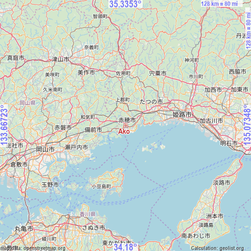
Ako GPS coordinates[2]
34° 45' 34.812" North, 134° 22' 13.26" East
| Map corner | latitude | longitude |
|---|---|---|
| Upper-left | 35.3353°, | 133.66723° |
| Center: | 34.75967°, | 134.37035° |
| Lower-right: | 34.18°, | 135.07348° |
| Map W x H: | 128.5×128.5 km | = 79.8×79.8mi |
| max Lat: | 45.40944° ⇑66.5% North |
| Ako: | 34.75967° |
| min Lat: | ⇓33.5% South 24.34478° |
| min Long | Ako | max Long |
| 123° | 134.37035° | 145.575° |
| W 26.6%⇐ | ⇒73.4% E |
Elevation
Elevation of Ako is 2 m = 7 ft, and this is 82.6 m = 271 ft below average elevation for this country.
| Max E: |
1086 m = 3563 ft | 96.8% |
| Avg. | 84.6 m = 278 ft | |
| Ako | 2 m = 7 ft | |
Min E: |
-2 m = -7 ft | 3.2% |
See also: Japan elevation on elevation.city.
Geographical zone
Ako is located in North temperate zone (between Tropic of Cancer and the Arctic Circle). Distance of this Northern Tropic circle is 1259 km =782.3 mi to South.| Distance of | km | miles | from Ako |
|---|---|---|---|
| North Pole | 6142.1 | 3816.5 | to North |
| Arctic Circle | 3536.3 | 2197.4 | to North |
| Tropic Cancer | 1259 | 782.3 | to South |
| Equator | 3864.9 | 2401.5 | to South |


Nearby cities:
15 places around Ako: (largest is in red/bold)
• Aioi
10.2 km =6.3 mi,  61°
61°
• Akaiwa
32.3 km =20.1 mi,  279°
279°
• Bizen
12.7 km =7.9 mi, 283°
• Himeji
30.8 km =19.1 mi,  78°
78°
• Kariya
1.8 km =1.1 mi,  120°
120°
• Mimasaka
34 km =21.1 mi,  336°
336°
• Setouchi
23.6 km =14.7 mi,  241°
241°
• Shirahamachō-usazakiminami
31.7 km =19.7 mi,  85°
85°
• Shisō
30.3 km =18.8 mi,  35°
35°
• Takasago
38.5 km =23.9 mi, 89°
• Tatsuno
17.7 km =11 mi, 63°
• Tatsunochō-tominaga
20.3 km =12.6 mi,  54°
54°
• Tonoshō
36 km =22.4 mi,  210°
210°
• Yamazakichō-nakabirose
31.3 km =19.4 mi,  31°
31°
• Yonedacho Sendo
41.6 km =25.8 mi, 87°
Sources, notices
• [Note1] Compared only with cities in Japan existing in our database
• [Src1] Map data: © OpenStreetMap contributors (CC-BY-SA)
• [Src2] Other city data from geonames.org with taken over terms of usage.
• [Src3] Geographical zone / Annual Mean Temperature by Robert A. Rohde @ Wikipedia
