Makubetsu geodata
Makubetsu (Hokkaido) is a populated place; located in Japan in Asia/Tokyo (GMT+9) time zone. With population of 25,935 people, there are 597 cities with bigger population in this country. Compared to other cities in Japan, 99.9% of cities are located further ↓South; 97.1% of cities are located further ←West and 53.8% of cities have lower elevation than Makubetsu. Note1


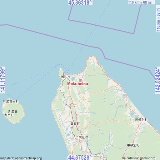
Makubetsu GPS coordinates[2]
45° 22' 17.004" North, 141° 49' 15.996" East
| Map corner | latitude | longitude |
|---|---|---|
| Upper-left | 45.86318°, | 141.11799° |
| Center: | 45.37139°, | 141.82111° |
| Lower-right: | 44.87528°, | 142.52424° |
| Map W x H: | 109.8×109.8 km | = 68.2×68.2mi |
| max Lat: | 45.40944° ⇑0.1% North |
| Makubetsu: | 45.37139° |
| min Lat: | ⇓99.9% South 24.34478° |
| min Long | Makubetsu | max Long |
| 123° | 141.82111° | 145.575° |
| W 97.1%⇐ | ⇒2.9% E |
Elevation
Elevation of Makubetsu is 33 m = 108 ft, and this is 51.6 m = 169 ft below average elevation for this country.
| Max E: |
1086 m = 3563 ft | 46.2% |
| Avg. | 84.6 m = 278 ft | |
| Makubetsu | 33 m = 108 ft | |
Min E: |
-2 m = -7 ft | 53.8% |
See also: Japan elevation on elevation.city.
Geographical zone
Makubetsu is located in North temperate zone (between Tropic of Cancer and the Arctic Circle). Distance of this North polar circle is 2356.3 km =1464.1 mi to North.| Distance of | km | miles | from Makubetsu |
|---|---|---|---|
| North Pole | 4962.2 | 3083.4 | to North |
| Arctic Circle | 2356.3 | 1464.1 | to North |
| Tropic Cancer | 2438.9 | 1515.5 | to South |
| Equator | 5044.8 | 3134.7 | to South |


Nearby cities:
15 places around Makubetsu: (largest is in red/bold)
• Akabira
203.2 km =126.3 mi,  174°
174°
• Asahikawa
183.1 km =113.8 mi, 166°
• Ashibetsu
209 km =129.9 mi, 172°
• Fukagawa
185.8 km =115.5 mi, 174°
• Kamikawa
186.1 km =115.6 mi,  156°
156°
• Mobetsu
172.3 km =107.1 mi,  135°
135°
• Mombetsu
165.5 km =102.8 mi,  133°
133°
• Nayoro
124.1 km =77.1 mi, 156°
• Rishiri Town
54.3 km =33.7 mi,  244°
244°
• Rumoi
160.4 km =99.7 mi,  185°
185°
• Shibetsu
140.9 km =87.6 mi, 161°
• Sunagawa
209.7 km =130.3 mi,  178°
178°
• Takikawa
202.3 km =125.7 mi, 178°
• Utashinai
207 km =128.6 mi, 174°
• Wakkanai
12.2 km =7.6 mi,  290°
290°
Sources, notices
• [Note1] Compared only with cities in Japan existing in our database
• [Src1] Map data: © OpenStreetMap contributors (CC-BY-SA)
• [Src2] Other city data from geonames.org with taken over terms of usage.
• [Src3] Geographical zone / Annual Mean Temperature by Robert A. Rohde @ Wikipedia
