Urasoe geodata
Urasoe (Okinawa) is a seat of a second-order administrative division; located in Japan in Asia/Tokyo (GMT+9) time zone. In our database, there are 767 cities with bigger population. Compared to other cities in Japan, 99.3% of cities are located further ↑North; 99.4% of cities are located further →East and 62% of cities have lower elevation than Urasoe. Note1


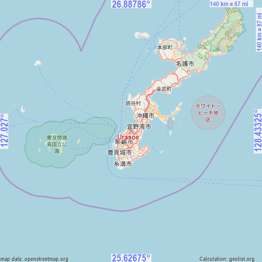
Urasoe GPS coordinates[2]
26° 15' 32.472" North, 127° 43' 48.432" East
| Map corner | latitude | longitude |
|---|---|---|
| Upper-left | 26.88786°, | 127.027° |
| Center: | 26.25902°, | 127.73012° |
| Lower-right: | 25.62675°, | 128.43325° |
| Map W x H: | 140.2×140.2 km | = 87.1×87.1mi |
| max Lat: | 45.40944° ⇑99.3% North |
| Urasoe: | 26.25902° |
| min Lat: | ⇓0.7% South 24.34478° |
| min Long | Urasoe | max Long |
| 123° | 127.73012° | 145.575° |
| W 0.6%⇐ | ⇒99.4% E |
Elevation
Elevation of Urasoe is 50 m = 164 ft, and this is 34.6 m = 114 ft below average elevation for this country.
| Max E: |
1086 m = 3563 ft | 38% |
| Avg. | 84.6 m = 278 ft | |
| Urasoe | 50 m = 164 ft | |
Min E: |
-2 m = -7 ft | 62% |
See also: Japan elevation on elevation.city.
Geographical zone
Urasoe is located in North temperate zone (between Tropic of Cancer and the Arctic Circle). Distance of this Northern Tropic circle is 313.8 km =195 mi to South.| Distance of | km | miles | from Urasoe |
|---|---|---|---|
| North Pole | 7087.3 | 4403.8 | to North |
| Arctic Circle | 4481.4 | 2784.6 | to North |
| Tropic Cancer | 313.8 | 195 | to South |
| Equator | 2919.7 | 1814.2 | to South |


Nearby cities:
15 places around Urasoe: (largest is in red/bold)
• Chatan
6.9 km =4.3 mi,  35°
35°
• Ginowan
3.2 km =2 mi,  82°
82°
• Gushikawa
17.7 km =11 mi,  50°
50°
• Hirara
292.4 km =181.7 mi,  236°
236°
• Ishikawa
20.4 km =12.7 mi,  26°
26°
• Itoman
15.9 km =9.9 mi,  202°
202°
• Katsuren-haebaru
16.5 km =10.3 mi,  60°
60°
• Miyakojima
292.5 km =181.8 mi, 236°
• Nago
47 km =29.2 mi, 32°
• Naha
6.6 km =4.1 mi,  224°
224°
• Nanjō
13.3 km =8.3 mi,  163°
163°
• Naze
291.4 km =181.1 mi, 36°
• Okinawa
11.1 km =6.9 mi, 39°
• Tomigusuku
9.5 km =5.9 mi,  210°
210°
• Uruma
18.3 km =11.4 mi, 44°
Sources, notices
• [Note1] Compared only with cities in Japan existing in our database
• [Src1] Map data: © OpenStreetMap contributors (CC-BY-SA)
• [Src2] Other city data from geonames.org with taken over terms of usage.
• [Src3] Geographical zone / Annual Mean Temperature by Robert A. Rohde @ Wikipedia
