Nago geodata
Nago (Okinawa) is a seat of a second-order administrative division; located in Japan in Asia/Tokyo (GMT+9) time zone. With population of 59,587 people, there are 326 cities with bigger population in this country. Compared to other cities in Japan, 98.5% of cities are located further ↑North; 98.5% of cities are located further →East and 53.2% of cities have lower elevation than Nago. Note1


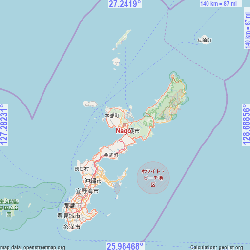
Nago GPS coordinates[2]
26° 36' 54.072" North, 127° 59' 7.548" East
| Map corner | latitude | longitude |
|---|---|---|
| Upper-left | 27.2419°, | 127.28231° |
| Center: | 26.61502°, | 127.98543° |
| Lower-right: | 25.98468°, | 128.68856° |
| Map W x H: | 139.8×139.8 km | = 86.9×86.9mi |
| max Lat: | 45.40944° ⇑98.5% North |
| Nago: | 26.61502° |
| min Lat: | ⇓1.5% South 24.34478° |
| min Long | Nago | max Long |
| 123° | 127.98543° | 145.575° |
| W 1.5%⇐ | ⇒98.5% E |
Elevation
Elevation of Nago is 32 m = 105 ft, and this is 52.6 m = 173 ft below average elevation for this country.
| Max E: |
1086 m = 3563 ft | 46.8% |
| Avg. | 84.6 m = 278 ft | |
| Nago | 32 m = 105 ft | |
Min E: |
-2 m = -7 ft | 53.2% |
See also: Nago elevation on elevation.city.
Geographical zone
Nago is located in North temperate zone (between Tropic of Cancer and the Arctic Circle). Distance of this Northern Tropic circle is 353.4 km =219.6 mi to South.| Distance of | km | miles | from Nago |
|---|---|---|---|
| North Pole | 7047.7 | 4379.2 | to North |
| Arctic Circle | 4441.9 | 2760.1 | to North |
| Tropic Cancer | 353.4 | 219.6 | to South |
| Equator | 2959.3 | 1838.8 | to South |


Nearby cities:
15 places around Nago: (largest is in red/bold)
• Amami
246 km =152.9 mi,  37°
37°
• Chatan
40.2 km =25 mi,  212°
212°
• Ginowan
45.1 km =28 mi, 209°
• Gushikawa
30.8 km =19.1 mi,  202°
202°
• Hirara
335.9 km =208.7 mi,  233°
233°
• Ishikawa
26.8 km =16.7 mi,  217°
217°
• Itoman
62.8 km =39 mi, 210°
• Katsuren-haebaru
33.3 km =20.7 mi, 199°
• Naha
53.5 km =33.2 mi, 214°
• Nanjō
56.7 km =35.2 mi, 202°
• Naze
244.5 km =151.9 mi, 37°
• Okinawa
36 km =22.4 mi, 210°
• Tomigusuku
56.5 km =35.1 mi, 212°
• Urasoe
47 km =29.2 mi, 212°
• Uruma
29.4 km =18.3 mi, 205°
Sources, notices
• [Note1] Compared only with cities in Japan existing in our database
• [Src1] Map data: © OpenStreetMap contributors (CC-BY-SA)
• [Src2] Other city data from geonames.org with taken over terms of usage.
• [Src3] Geographical zone / Annual Mean Temperature by Robert A. Rohde @ Wikipedia
