Nanjō geodata
Nanjō (Okinawa) is a seat of a second-order administrative division; located in Japan in Asia/Tokyo (GMT+9) time zone. In our database, there are 767 cities with bigger population. Compared to other cities in Japan, 99.5% of cities are located further ↑North; 99.2% of cities are located further →East and 74.1% of cities have lower elevation than Nanjō. Note1


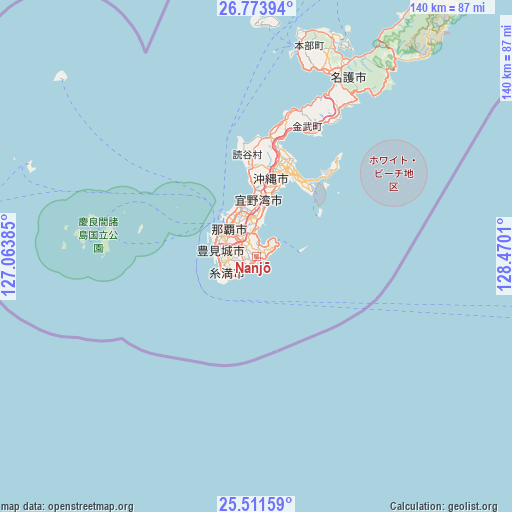
Nanjō GPS coordinates[2]
26° 8' 40.092" North, 127° 46' 1.092" East
| Map corner | latitude | longitude |
|---|---|---|
| Upper-left | 26.77394°, | 127.06385° |
| Center: | 26.14447°, | 127.76697° |
| Lower-right: | 25.51159°, | 128.4701° |
| Map W x H: | 140.4×140.4 km | = 87.2×87.2mi |
| max Lat: | 45.40944° ⇑99.5% North |
| Nanjō: | 26.14447° |
| min Lat: | ⇓0.5% South 24.34478° |
| min Long | Nanjō | max Long |
| 123° | 127.76697° | 145.575° |
| W 0.8%⇐ | ⇒99.2% E |
Elevation
Elevation of Nanjō is 92 m = 302 ft, and this is 7.4 m = 24 ft above average elevation for this country.
| Max E: |
1086 m = 3563 ft | 25.9% |
| Nanjō | 92 m 302 ft | |
| Avg. | 84.6 m = 278 ft | |
Min E: |
-2 m = -7 ft | 74.1% |
See also: Japan elevation on elevation.city.
Geographical zone
Nanjō is located in North temperate zone (between Tropic of Cancer and the Arctic Circle). Distance of this Northern Tropic circle is 301.1 km =187.1 mi to South.| Distance of | km | miles | from Nanjō |
|---|---|---|---|
| North Pole | 7100.1 | 4411.8 | to North |
| Arctic Circle | 4494.2 | 2792.6 | to North |
| Tropic Cancer | 301.1 | 187.1 | to South |
| Equator | 2907 | 1806.3 | to South |


Nearby cities:
15 places around Nanjō: (largest is in red/bold)
• Chatan
18.4 km =11.4 mi,  1°
1°
• Ginowan
13.2 km =8.2 mi,  357°
357°
• Gushikawa
25.9 km =16.1 mi,  22°
22°
• Hirara
288.8 km =179.5 mi,  238°
238°
• Ishikawa
31.5 km =19.6 mi,  9°
9°
• Itoman
10 km =6.2 mi,  258°
258°
• Katsuren-haebaru
23.5 km =14.6 mi,  26°
26°
• Miyakojima
288.9 km =179.5 mi, 238°
• Nago
56.7 km =35.2 mi, 22°
• Naha
11.6 km =7.2 mi,  313°
313°
• Naze
299.7 km =186.2 mi, 34°
• Okinawa
21.6 km =13.4 mi, 9°
• Tomigusuku
9.7 km =6 mi,  298°
298°
• Urasoe
13.3 km =8.3 mi,  343°
343°
• Uruma
27.3 km =17 mi, 19°
Sources, notices
• [Note1] Compared only with cities in Japan existing in our database
• [Src1] Map data: © OpenStreetMap contributors (CC-BY-SA)
• [Src2] Other city data from geonames.org with taken over terms of usage.
• [Src3] Geographical zone / Annual Mean Temperature by Robert A. Rohde @ Wikipedia
