Katsuren-haebaru geodata
Katsuren-haebaru (Okinawa) is a populated place; located in Japan in Asia/Tokyo (GMT+9) time zone. With population of 34,239 people, there are 507 cities with bigger population in this country. Compared to other cities in Japan, 99% of cities are located further ↑North; 98.6% of cities are located further →East and 76.3% of cities have higher elevation than Katsuren-haebaru. Note1


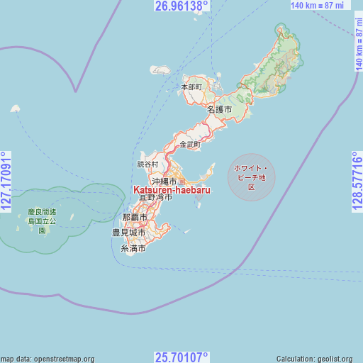
Katsuren-haebaru GPS coordinates[2]
26° 19' 58.584" North, 127° 52' 26.508" East
| Map corner | latitude | longitude |
|---|---|---|
| Upper-left | 26.96138°, | 127.17091° |
| Center: | 26.33294°, | 127.87403° |
| Lower-right: | 25.70107°, | 128.57716° |
| Map W x H: | 140.1×140.1 km | = 87.1×87.1mi |
| max Lat: | 45.40944° ⇑99% North |
| Katsuren-haebaru: | 26.33294° |
| min Lat: | ⇓1% South 24.34478° |
| min Long | Katsuren-haebar | max Long |
| 123° | 127.87403° | 145.575° |
| W 1.4%⇐ | ⇒98.6% E |
Elevation
Elevation of Katsuren-haebaru is 9 m = 30 ft, and this is 75.6 m = 248 ft below average elevation for this country.
| Max E: |
1086 m = 3563 ft | 76.3% |
| Avg. | 84.6 m = 278 ft | |
| Katsuren-haebaru | 9 m = 30 ft | |
Min E: |
-2 m = -7 ft | 23.7% |
See also: Japan elevation on elevation.city.
Geographical zone
Katsuren-haebaru is located in North temperate zone (between Tropic of Cancer and the Arctic Circle). Distance of this Northern Tropic circle is 322 km =200.1 mi to South.| Distance of | km | miles | from Katsuren-haebaru |
|---|---|---|---|
| North Pole | 7079.1 | 4398.7 | to North |
| Arctic Circle | 4473.2 | 2779.5 | to North |
| Tropic Cancer | 322 | 200.1 | to South |
| Equator | 2927.9 | 1819.3 | to South |


Nearby cities:
15 places around Katsuren-haebaru: (largest is in red/bold)
• Amami
277.9 km =172.7 mi,  35°
35°
• Chatan
10.7 km =6.6 mi,  255°
255°
• Ginowan
13.7 km =8.5 mi,  235°
235°
• Gushikawa
3 km =1.9 mi,  347°
347°
• Hirara
308.9 km =191.9 mi, 236°
• Ishikawa
11.3 km =7 mi,  332°
332°
• Itoman
30.7 km =19.1 mi,  221°
221°
• Nago
33.3 km =20.7 mi,  19°
19°
• Naha
23 km =14.3 mi, 235°
• Nanjō
23.5 km =14.6 mi,  206°
206°
• Naze
276.4 km =171.7 mi, 35°
• Okinawa
7.2 km =4.5 mi,  272°
272°
• Tomigusuku
25.2 km =15.7 mi,  229°
229°
• Urasoe
16.5 km =10.3 mi, 240°
• Uruma
5 km =3.1 mi,  342°
342°
Sources, notices
• [Note1] Compared only with cities in Japan existing in our database
• [Src1] Map data: © OpenStreetMap contributors (CC-BY-SA)
• [Src2] Other city data from geonames.org with taken over terms of usage.
• [Src3] Geographical zone / Annual Mean Temperature by Robert A. Rohde @ Wikipedia
