Ishikawa geodata
Ishikawa (Okinawa) is a populated place; located in Japan in Asia/Tokyo (GMT+9) time zone. With population of 22,412 people, there are 654 cities with bigger population in this country. Compared to other cities in Japan, 98.6% of cities are located further ↑North; 98.9% of cities are located further →East and 71.1% of cities have higher elevation than Ishikawa. Note1


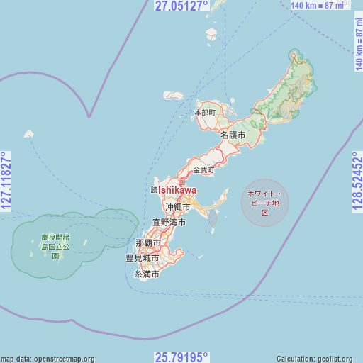
Ishikawa GPS coordinates[2]
26° 25' 23.988" North, 127° 49' 17.004" East
| Map corner | latitude | longitude |
|---|---|---|
| Upper-left | 27.05127°, | 127.11827° |
| Center: | 26.42333°, | 127.82139° |
| Lower-right: | 25.79195°, | 128.52452° |
| Map W x H: | 140×140 km | = 87×87mi |
| max Lat: | 45.40944° ⇑98.6% North |
| Ishikawa: | 26.42333° |
| min Lat: | ⇓1.4% South 24.34478° |
| min Long | Ishikawa | max Long |
| 123° | 127.82139° | 145.575° |
| W 1.1%⇐ | ⇒98.9% E |
Elevation
Elevation of Ishikawa is 11 m = 36 ft, and this is 73.6 m = 241 ft below average elevation for this country.
| Max E: |
1086 m = 3563 ft | 71.1% |
| Avg. | 84.6 m = 278 ft | |
| Ishikawa | 11 m = 36 ft | |
Min E: |
-2 m = -7 ft | 28.9% |
See also: Japan elevation on elevation.city.
Geographical zone
Ishikawa is located in North temperate zone (between Tropic of Cancer and the Arctic Circle). Distance of this Northern Tropic circle is 332.1 km =206.4 mi to South.| Distance of | km | miles | from Ishikawa |
|---|---|---|---|
| North Pole | 7069.1 | 4392.5 | to North |
| Arctic Circle | 4463.2 | 2773.3 | to North |
| Tropic Cancer | 332.1 | 206.4 | to South |
| Equator | 2938 | 1825.6 | to South |


Nearby cities:
15 places around Ishikawa: (largest is in red/bold)
• Amami
272.8 km =169.5 mi,  37°
37°
• Chatan
13.6 km =8.5 mi,  201°
201°
• Ginowan
18.8 km =11.7 mi, 198°
• Gushikawa
8.5 km =5.3 mi,  147°
147°
• Hirara
310.2 km =192.7 mi,  234°
234°
• Itoman
36.3 km =22.6 mi, 204°
• Katsuren-haebaru
11.3 km =7 mi, 152°
• Nago
26.8 km =16.7 mi, 37°
• Naha
26.8 km =16.7 mi,  210°
210°
• Nanjō
31.5 km =19.6 mi,  189°
189°
• Naze
271.3 km =168.6 mi, 37°
• Okinawa
9.9 km =6.2 mi, 191°
• Tomigusuku
29.8 km =18.5 mi, 207°
• Urasoe
20.4 km =12.7 mi, 206°
• Uruma
6.5 km =4 mi,  144°
144°
Sources, notices
• [Note1] Compared only with cities in Japan existing in our database
• [Src1] Map data: © OpenStreetMap contributors (CC-BY-SA)
• [Src2] Other city data from geonames.org with taken over terms of usage.
• [Src3] Geographical zone / Annual Mean Temperature by Robert A. Rohde @ Wikipedia
