Thika geodata
Thika (Nairobi Area) is a populated place; located in Kenya in Africa/Nairobi (GMT+3) time zone. With population of 200,000 people, there are 5 cities with bigger population in this country. Compared to other cities in Kenya, 67.5% of cities are located further ↑North; 62.3% of cities are located further ←West and 55.3% of cities have lower elevation than Thika. Note1


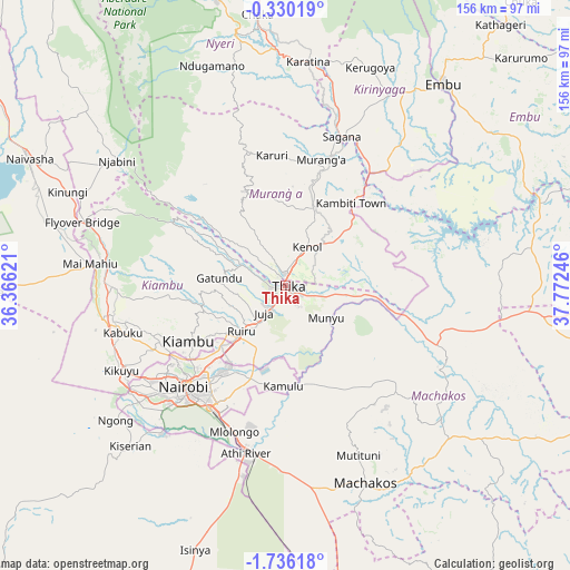
Thika GPS coordinates[2]
1° 1' 59.736" South, 37° 4' 9.588" East
| Map corner | latitude | longitude |
|---|---|---|
| Upper-left | -0.33019°, | 36.36621° |
| Center: | -1.03326°, | 37.06933° |
| Lower-right: | -1.73618°, | 37.77246° |
| Map W x H: | 156.3×156.3 km | = 97.1×97.1mi |
| max Lat: | 3.93726° ⇑67.5% North |
| Thika: | -1.03326° |
| min Lat: | ⇓32.5% South -4.64756° |
| min Long | Thika | max Long |
| 33.97248° | 37.06933° | 41.85688° |
| W 62.3%⇐ | ⇒37.7% E |
Elevation
Elevation of Thika is 1506 m = 4941 ft, and this is 159.3 m = 523 ft above average elevation for this country.
| Max E: |
2514 m = 8248 ft | 44.7% |
| Thika | 1506 m 4941 ft | |
| Avg. | 1346.7 m = 4418 ft | |
Min E: |
7 m = 23 ft | 55.3% |
See also: Thika elevation on elevation.city.
Geographical zone
Thika is located in South Torrid zone (between Equator and Tropic of Capricorn). Distance of Equator is 114.9 km =71.4 mi to North.| Distance of | km | miles | from Thika |
|---|---|---|---|
| Equator | 114.9 | 71.4 | to North |
| Tropic Capricorn | 2491 | 1547.8 | to South |
| Antarctic Circle | 7286.3 | 4527.5 | to South |
| South Pole | 9892.2 | 6146.7 | to South |


Nearby cities:
15 places around Thika: (largest is in red/bold)
• Athi River
48.1 km =29.9 mi,  192°
192°
• Kandara
16.8 km =10.4 mi,  333°
333°
• Kangema
40.4 km =25.1 mi,  343°
343°
• Kangundo
43.2 km =26.8 mi,  134°
134°
• Karuri
39.2 km =24.4 mi,  18°
18°
• Kiambu
30.2 km =18.8 mi,  239°
239°
• Kijabe
56.4 km =35 mi,  281°
281°
• Kikuyu
51 km =31.7 mi, 242°
• Limuru
48.3 km =30 mi,  259°
259°
• Maragua
27.3 km =17 mi, 15°
• Murang’a
35.9 km =22.3 mi,  14°
14°
• Nairobi
39.5 km =24.5 mi,  225°
225°
• Othaya
56.2 km =34.9 mi, 344°
• Pumwani
37 km =23 mi,  221°
221°
• Sagana
43.5 km =27 mi, 20°
Sources, notices
• [Note1] Compared only with cities in Kenya existing in our database
• [Src1] Map data: © OpenStreetMap contributors (CC-BY-SA)
• [Src2] Other city data from geonames.org with taken over terms of usage.
• [Src3] Geographical zone / Annual Mean Temperature by Robert A. Rohde @ Wikipedia
